This was converted in July 2018 by Nat Taylor from the PDF available at bostonplans.org
The goal is to make it more readable, especially on phones/tablets and as such the positioning of some of the figures has changed and some typographical errors are present due to the image-to-text conversion.
Please submit corrections to nattaylor@gmail.com
April 2000
Dear East Boston Friends:
It gives me great pleasure to release the East Boston Master Plan. This document is a community-based plan that establishes the framework lot Future development in East Boston, ensuring that the community’s voice is heard before development occurs. The plan provides a balance between a variety of competing interests, all of Which are important. Thank you for all of your long hours at community meetings, thoughtful public comments and willingness to work together – as a community W for the greater good.
East Boston’s proximity to downtown, its historic waterfront, and diverse population make the neighborhood one of the city’s best-kept secrets, As the waterfront evolves from a busy maritime industrial port to a mix of industrial, commercial, residential and recreational uses, many exciting opportunities for economic development are created. Development should and will be balanced and thoughtful. With this plan, your vision has laid the groundwork so that all future economic development will benefit the entire community, and no one will be left behind.
The Master Plan also builds upon East Boston’s natural and cultural resources. With the implementation of the open space strategy laid out in this plan, residents of East Boston will enjoy one of the highest concentrations of open space per square mile in our city. This is just one of the exciting prospects that have come out of the Master Planning efforts,
Strengthening neighborhoods, reviving the waterfront, enhancing commercial centers, energizing the McClellan Highway / upper Chelsea Creek corridor and seizing balanced economic development opportunities are all central themes in this plan. l look forward to continuing our work together. Our next step is to draft and submit to the state 3 Municipal Harbor Plan that Will enable your vision for the waterfront to be realized.
Please stay engaged in this important process. Together we are reshaping one of the City of Boston’s greatest assets - its neighborhoods.
Thomas M. Menino Mayor of Boston
The East Boston Master Plan provides a framework for new growth and development in the community’s commercial districts and waterfront area, while preserving and enhancing the quality of life in the community’s adjacent residential neighborhoods. Beginning in the 18305, when East Boston has developed as a residential neighborhood and commercial district, through the thriving economic period of shipbuilding and maritime industry and in the present period of major transportation and infrastructure development, East Boston has maintained a distinct physical and demographic identity. Immigrants to the region have Frequently settled in East Boston, drawn initially by employment Opportunities and proximity to the down, town and remaining because of the stock of affordable housing and the clear sense of community, among Other features. Today, the diversity created by this continuing immigration is one of the community’s greatest strengths.
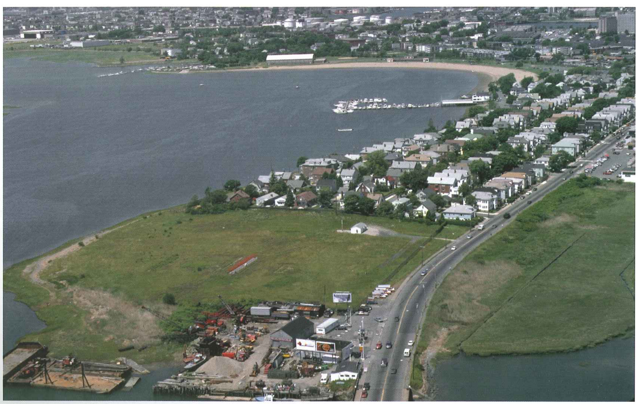
East Boston, like other waterfront communities in New England, has been impacted by the severe decline in traditional water dependent industries. Despite that fact that the number of jobs related to these industries has declined over the decades, a strong community environment, improved rapid transit and vehicular connections to downtown Boston, and airport related economic opportunities work together to make the community a desirable place to live. And while East Boston’s harbor front is today a substantially underutilized asset, it is a major component of Boston Harbor, supporting residential, recreational, tourism, and traditional port activities.
The East Boston Master Plan provides a means to take full advantage of these assets. No master plan is cast in stone; to be successful, a master plan must provide an overall vision while remaining flexible and responsive to unforeseen opportunities and changes in circumstances that may arise while the plan is carried out. The Master Plan represents the result of a broad-based Community process. It is the product of several years of goal-setting, the evaluation of alternative development scenarios, and a careful reviewing of alternatives for feasibility.
Chapter One provides an overview of the East Boston Master Plan.
Chapter Two presents a summary of the planning process and public involvement and describes current projects and planning efforts and provides a real estate market assessment.
Chapter Three presents the key elements of the Plan and describes recommended actions within each geographic area.
Chapter Four presents implementation recommendations.
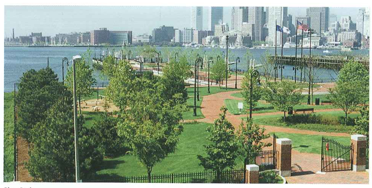
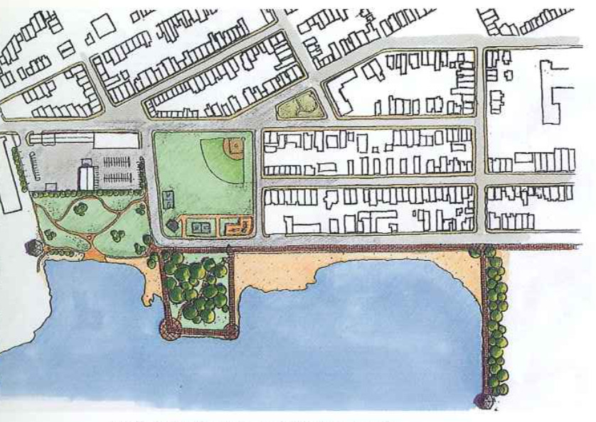
Piers Park demonstrates the pattern of development that should continue in the future. TO either side of the park, the anticipation of positive change will soon be fulfilled. Piers Park will be extended to land adjoining, the nearby Shipyard will be revitalized, and a new waterfront neighborhood of housing with inviting public uses and outdoor open space will soon be developed. Supported by the renewed activity on and around the waterfront, ferry service will again be running to downtown Boston. The new East Boston Greenway will provide a unique linear open space, linking Piers Park and East Boston’s waterfront with several of the community’s neighborhoods and a restored Constitution Beach.
And nearby, in the local commercial districts and residential neighborhoods from Maverick Square to Orient Heights, orderly growth and change is taking hold.
The Master Plan describes planning for East Boston’s waterfront and its maritime-related industries. It describes methods to protect and enhance existing residential neighborhoods, what role the community’s history will play in Future development, and what new economic development opportunities exist along the harborfront and in the community’s various commercial districts. Descriptions of some of the key elements of the Plan are provided in this section. They are the building blocks of the Master Plan: urban design, transportation, open space, and economic development.
In the near future, residents and Visitors alike will be able to emerge from a new Maverick Station on the Blue Line and stroll down Lewis Mall with the skyline of the Financial District in full view. The handsomely paved and landscaped pedestrian way will be the “Main Street” of a new waterfront residential district, stretching from Piers Park to LoPresti Park. It will be lined with shops, cafes, and other public spaces 7 including community space and possibly a museum. At the foot of the Mall, at revived ferry service, supported by the new residents, and increased retail activity at the water’s edge in East Boston, will once again link the neighborhood with the Financial District and downtown.
Within East Boston, access to and around the waterfront also Will be enhanced. The East Boston Greenway will link the community’s neighborhoods From Piers Park to Constitution Beach. The series of streets that run along the waterfront, from Marginal Street at Piers Park to Condor Street along Chelsea Creek, are physically linked with a new public way through Clippership Wharf, and visually connected through a common streetscape treatment as East Boston’s ’Waterfront Way." Chelsea Creek and its waterfront, still an active industrial area, are being cleaned and improved. The Condor Street Urban Wilds site is being transformed into another neighborhood park, joined by a 1,200 foot segment of Harborwalk along the Creek to an observation point at the bulkhead line of the former Hess Oil site.

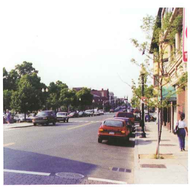
As new economic development begins to transform the East Boston waterfront, East Boston’s current and new residents will see benefits in the community’s neighborhood commercial centers as well. The success of the Main Streets program for both Maverick and Central Squares in improving the appearance and vitality of East Boston’s main business districts can be expanded to Orient Heights and Day Square. Streetscape improvements in each square will simplify traffic patterns, remove excess asphalt and increase pedestrian space. In Central Square, modifications to Liberty Plaza Will also provide batter pedestrian connections, both to the sweet and to the waterfront, which today lies hidden and inaccessible immediately behind. At Maverick Square, the reconstruction of the Blue Line station will also create a more pedestrian-friendly environment, with streetscape enhancements and widened sidewalks that will provide space for outdoor cafes.
East Boston has historically suffered from insufficient open space, and loss of Wood Island Park to airport expansion is a painful memory for Iong-time residents. However, in the: next few years the increase in the amount and variety of high-quality open space available to East Boston residents, especially along the waterfront, will be even more dramatic than the amount of new building construction. Piers Park II and the likely park development of Massport’s Pier 5 Will more than double the size of the current 6.5 acre Piers Park. Along Chelsea Creek, the improvement of the Condor
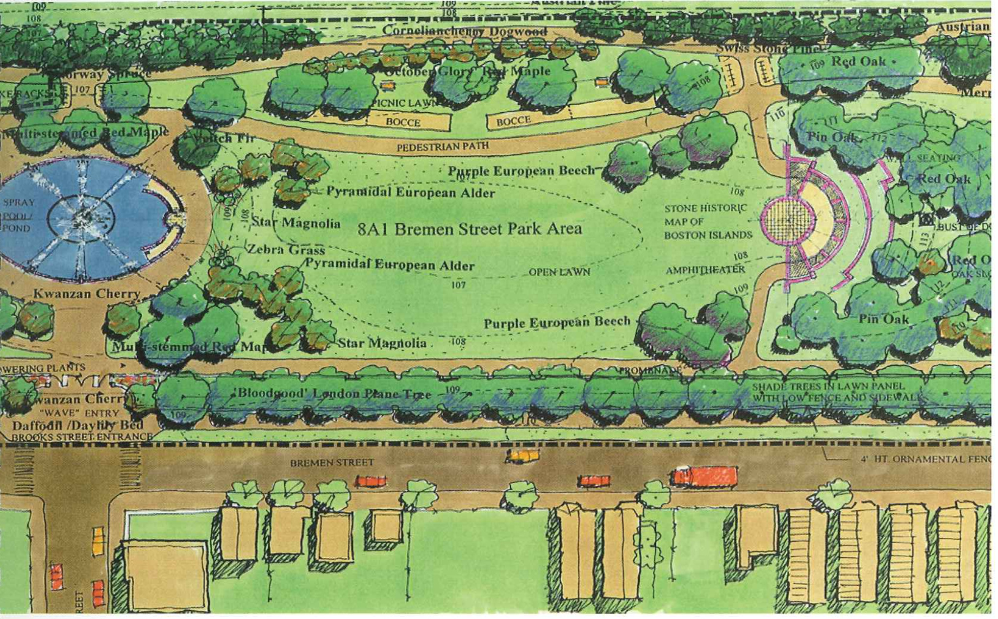
Street Urban Wilds will add another waterfront park setting for Eagle Hill residents who can walk along the Creek on Condor Street and continue out to the bulkhead via a landscaped pedestrian walk on the former Hess Oil site. The new Bremen Street Park, restored and improved Memorial Stadium complex, and the East Boston Greenway provide additional amenities and recreational opportunities for both community residents and visitors. The Metropolitan District Commission’s restoration of Constitution Beach, including much improved access and facilities, and the nearby Belle Isle Marsh, provide an unmatched diversity of open space and recreational opportunities within an urban setting.
The history of East Boston will also come alive in and around this network of open spaces. A series of interpretive kiosks will be placed at intervals along the waterfront, as a component of an expanded Harborwalk A community room in the new East Boston Sailing Center at Piers Park II will provide waterfront meeting space and an opportunity for educational programs for schools. In addition, a series of decorative gateways, designed with community input and erected with a grant From the Robert ingersoll Browne Fund. will help to establish a unique sense of place at each location.
While new housing and open space development is occurring around the perimeter of the community, East Boston’s core 7 its varied and close-knit residential neighborhoods will be protected from unwanted development impacts and enhanced through small-scale, community-sensitive treatments. Market studies indicate that demand for homeownership and rental housing opportunities; in East Boston is high. Fortunately, opportunities for infill housing development to respond to this demand can be found throughout the c0m~ munity. Other sites might be devoted to vest-pocket Off-street resident parking lots or community gardens. The triangular mixed use neighborhood bounded by Central and Maverick Squares and the waterfront presents a special opportunity for a combination of infill and larger scale development. The City owned Boston East site on the waterfront could be an attractive location for potential artist live-work space similar to the existing community along the Fort Point Channel. Traffic calming measures will help to ensure that the quiet residential side streets of the community stay that way. With the neighborhood parking crunch eased by off-street locations, some of the unique triangular intersections on Eagle Hill may be freed of their use as parking lots and converted into neighborhood greens.
In summary, the East Boston Master Plan provides:
Implementation of the Master Plan can begin immediately as it has been accepted by key parties. The Plan identifies projects that can be accomplished in the short term, as well as establishes mid- and long-range priorities that will require further planning, design, and development.
The Master Plan is being finished at a time when resources and opportunities are available to resolve longstanding issues in revitalizing East Boston and to realize a well planned, community-based vision for East Boston.
The Boston Redevelopment Authority (ERA) and the eommunity-based Planning Coordinating Group (PCG), building upon the process initiated by the Comprehensive Hamming Initiative (CPD, have worked together over the past year to develop the East Boston Master Plan. The PCG is an 18-11mmber group representing diverse organizations in East Boston. Its monthly meetr ings, which have been open to the pub; lie, have been well attended by members of the community.

The PCG has reviewed and discussed each key step in the development of the Master Plan:
Existing Conditions - land use, transportation systems, and economic market analyses.
Planning Areas 7 key Characteristics to create a framework for planning analysis.
Focus Issues 7 topics of concern to be addressed by the Master Plan.
Goals and Evaluation Criteria - framework for developing the Master Plan.
Planning Alternatives and Strategies _ three different approaches to the Master Plan.
Preferred Alternative 7 recommended approach based on community ideas and opinions.
Three workshops and two community meetings provided the opportunity for public input at each major decision point in the deve1opment of the Master Plan. Attendance ranged between 75 to 100 people at the following meetings and workshops:
Kick-Of-f Meeting, June 30, 1998 to describe the planning process and introduce BRA staff and its team. Participants were also asked to share their thoughts on issues of concern through a survey form.
Issues/Opportunities in Warming Areas Workshop, October 14, 1998 was pre ceded by a neighborhood bus tour and followed by the workshop at Which participants discussed critical issues for the Waterfront, Business District/Gateways, and Neighborhoods and Connectors planning areas. Alternatives Workshop, December 9, 1998 at which participants were asked to indicate strengths and weaknesses of the three alternatives presented.
Alternatives Evaluation Workshop, March 10, 1999 presented the preferred alternative evaluation and recommendations. The participants were asked to provide opinions about the waterfront sub-option choices and to indicate pT’Ile otities for the waterfront, neighborhood and transportation, and economic deve1opmer1t eiements.
Draft Master Plan Public Meeting, May 26, 1999 to review the draft Master Plan with the community and provide an opportunity for comments before finalizing the Plan.
Public Outreach 7 Each workshop involved community-wide distribution of a bilingual (English and Spanish) BRA bulletin describing the outcome of the previous workshop and purpose of the upcoming workshop and other pertinent information. Workshops were well publicized with notices and radio announcements in English and Spanish.
Throughout the process, the BRA met with elected ofiicials, individuals, businesses, and other interested parties for briefing and discussion purposes. A focus group discussion on neighbor; hood commercial centers was he1d with individuais representing business, residential, and ethnic community interests to test ideas about the retail and come mercial opportunities of the centers.
Technical Memoranda and workshop materials were made avai1ab1e for review at East Boston libraries and the Harborside Community Center and on the Internet in order to afford individuals additiona1 opportunity to study the information and provide comments to the BRA. The large attendance at the PCS meetings and the workshops demonstrated the eomrnunitfs interest and involvement in the planning process and provided extensive feedback on the Plan as it evolved.
Coordination The BRA coordinated the development of the Master Plan With key city and state agencies as well as sponsors of ongoing development projects, such as the Massport Piers and Clippership Wharf.
Consensus - The BRA worked toward consensus among the parties affected by the Master Plan. As individual projects are implemented, the City will continue to provide opportunities for community involvement and review. It is expected that the Master Plan Will be amended in the future to meet changing conditions.
Through the planning process, a set of goals and objectives were created that reflect the community’s desire to maintain East Bostorfs identity and culture While accomodating new and innovative land uses in the future. The Master Plan includes the following goals:
The East Boston Master Plan process has identified concurrent planning efforts “in the pipeline”. The purpose of outlining the improvements currently planned is to understand the actions which will occur regardless of the: Master Plan. However, for projects early in their development process, the Master Plan provides recommendations reflecting public comments. The Master Plan attempts to use these current trends to guide development toward the goals of the community. This section will briefly describe the major planning efforts already underway a that affect the Master Plan and East Boston.

Reconnect - An East Boston of the Future, 1989 establishes a framework for development possibilities at various areas in East Boston.
Urban Design Study - Airport Edge, January 1993 is a starting point for discussion of compatible uses adjacent to Logan Airport and the East Boston community. Existing conditions, possible uses, and design options are the sections addressed in the design explon ration of six sites around the Airport.
Orient Heights Station Area Circulation Study, November 1994 evaluates options and identifies the safest long term strategy for bus and passenger/parlcing circulate fion at the Orient Heights station.
East Boston: Building Momen turn for Change, June 1995 summarizes a consensus building workshop that was conducted by architect Antonio DiMambro With participating East Boston community groups.
Port of Boston - Economic Development Plan, March 1996, investigates the various mar ket sectors that the Port of Boston served in the past and Will serve in the Future.
Results of the September 21, 1996 Community Planning Day are listings Of comments from discussions held in small issue work groups regarding various important planning topics includ ing: economic development, housing, community safety, human services, education, open space, health, arts/eulture/heritage, and transportation.
Chelsea Creek Study - Introduction, August 1997 serves as a starting point for discussion on how groups could work together to impact the environ mental issues surrounding the Chelsea Creek.
After examining baseline improvements in the first section of this chapter, this section, Market Assessment, will examine the feasibility of the planning framework given various market forces.
Economic growth is evident in Virtually every economic sector in East Boston. East Boston shows significant improvement in all sectors since the trough of the recession, as measured in sales, expenditures, employment, occupied square feet and available housing units. This improvement arises largely from East Boston’s participation in an expanding regional economy; however, East Boston’s share of the regional markets shows moderating declines or stability in almost all sectors. Without continued effort, East Boston’s economic growth is vulnerable to regional competition (especially if there should be a general economic downturn). East Bostonis local economy is also small in size, Which creates a vulnerability to the fortunes of individual companies, prop; erty owners, and industries.
Significantly improving competitive positioning Will require implementation of major new public and private initiae tives. A lack of proactive effort would likely lead to a loss of market share and increased vulnerability to external market conditions. East Bostonls current and future market positioning relies to a great degree on its competitive strengths, Which include its proximity to downtown Boston and Logan International Airport, its wateifront location and facilities, its established businesses and institutions, its physical quality, and its relative affordability These factors can be used to stabilize and improve East Bostonls economic condition.
Specific opportunities exist for East Boston to capture a larger share of the neighborhood retail, marine-services, industrial, residential, and hospitality markets. An expanded neighborhood retail market would include improved sales at existing facilities and new retail and restaurant development Within the existing commercial nodes. The matine-services market would include expanded water-side activities (commere eial and recreational dockage, water transportation, exeursion/chatter usage) and expanded landside supports (toilets/showers, boat repair, storage} retail, and restaurants). improved occupancy and utilization at existing marine industrial facilities and the development of new and expanded non-wateredepencb ent industrial facilities Within the McClellan Highway corridor would be included in industrial market expann sion. Renovations of existing residential properties, conversion of obsolete industrial/eommereial properties, and the development of new rental and ownership housing stock would be implemented for the residential market. New facilities otiented to the business traveler and tourism markets would be included in the hcspitality sector.
Specific limitations will have to be overcome for East Boston to capture a larger share of the market. These limitations include issues relating to cost, regulations, transportation, and community involvement. One specific factor is the high cost of (re)development relative to real estate prices in East Boston (especially including land costs, waterside infrastructure costs, parking costs, and landside development premiums). Another economic issue is the high cost of converting/redeveloping existing uses to more productive uses. There are regulatory limitations/conditions for cere tain uses of the waterfront (especially non-watet dependent) and there is limited land available for new develop ment. Two additional market con" straints relate to the perceived inconvenience of vehicular access to clowntown Boston and the perceived difl’lculu ty of a community review process
Growing regional buying power is anticipated over the next 5-10 years. This gTowth suggests an expanded demand for regiOH-serving retail services such as apparel, household goods, gifts, eating and drinking. East Boston resident expenditures are stable- to- grewing, suggesting modest growth for tradition al communitywserving retail (food, drugs, liquor, and sundries). Substantial local sales capture in some merchandise eategon’es (eating and drinking, drugs/personal care, liquor, automotive, miscellaneous retail, building materials) indicate the importance of non-resident expenditures to market sales, while limited sales capture in others (foodeatshome, apparel, furniture) indicate potential untapped market opportunities. The area shows relatively low retail vacancy rates, but also a significant undersutilization of space (relatively low sales volumes/SF). There is positive Financial feasibility for rehabilii tation of existing retail property and for instill development in established retail districts, but there is limited financial feasibility for new free-stancling retail development 9f scale.
There are several competitive advane tages and disadvantages relating to growth in the retail sector fer East Boston. The area shows significant evir dence of entrepreneurial activity and investment. Existing retail space within the districts is well concentrated, with each district having wellidefined. bound, aries and an identifiable retail theme or demand focus. There are also significant niche market opportunities for groups such as tourists, waterfront users, daytime employees, commuters, and neighborhood residents. Low leaSe rates, the presence of major demand generators (i.e. Logan Airport), and reai sonably good availability of public parking all contribute to potential for positive retail Opportunities in East Boston. Limitations in quality space options and land available for new development might hamper development, while cost sensitivity of the market may also hinder the feasibility of maj or rehabilitation and new construction activity.
Growth is expected near term in all demand sectors of the hospitality indus try. it is especially strong in the uextended stay}, business traveler and teunsm sectors. However, the limited morn supply in East Boston currently results in the diversion of business and tourism demand to other locations. This is particularly treublesome given the economic potential lost When more affluent, longer-stay business users and visitors take their spending power out Of the neighborhood. Near term financial feasibility is positive for ilextenclecl stayu hotels oriented to cost conscious visitors (business and tourist) room-rate and product requirements, and is limited for new waterfront hotel develop ment.
There are several competitive advan[ages and disadvantages relating to growth in the hospitality sector for East Boston. The presence of major demand generators (e.g., Logan Airpert) add to significant niche market opportunities. There is also potential for relatively affordable pricing. However, there are limited sites with highway access, visibility, and/or presencegwhich would be key to the business market_and access to dewntown Boston is perceived to be difficult.
There is a growing demand in both office and Research and Development (R&D) sectors in the region, but a shrinking market share for East Boston: which shows low vacancy rates and little or 110 recent new development in these sectors. However, competitive rates and positive near term financial feasibility for upper floor office space in existing commercial districts demonstrate positive near term financial feasii bility. Limited near term financial feasibility exism for new freestanding effices 01’ R&D development, except for llhuills tosuitl’ occupants.
There are several competitive advantages and disadvantages relating to gTowth in the Office and R&D sectors fer East Boston. Low lease rates, good public transportation, the presence of a major demand generator (Logan Airport) and niche market themes/attractiens such as waterfront, tourism, history, and architecture are all positive [actors in the areas development. However, Cost sensitivity of the market and developable land con straints may hinder the feasibility of major rehabilitation and new construction activity. There are limited sites with access/visibility from major highi ways and limited quality space options currently available for either office or R&D users. The shrinking market share is likely to continue unless active steps are taken to support exjsting businesses and to promote business retention and internal growth.
There is a shrinking though stabilizing demand in city-wide industrial employment and a growing airport-related industn’al demand resulting from ecor nomic expansion and diminishing supply (3f space on airport property. Although airportirelated industrial vacancy rates are low, several new airport-related industrial facilities are in the planning stages. There is also a shrinking marine industrial demand.
however, the market is active for existing lower intensity maritime users {marine services, marine construction, boat repair; staging, storage, and layover berthing). There are high rates of existing underutilized marine industrial properties and no recent new man’ne industrial development. Without subsidy, a limited short and long term feasibility for new marine industrial development is projected. There is positive near term Emancial feasibility for new non-marine industrial development, and East Boston boasts competitive lease rates.
There are several competitive advann rages and disadvantages relating to growth in the industrial sectors for East Beaten. The presence 0f Legan Airport and niche market themes/attractions (airport proximity, deep water berthing, accessible Inner Harbor location) work tOwarcl growth in East Boston. The area boasts relatively low lease rates on the underutilized land with expensive waterside infrastructure needs. Elsewhere cost sensitivity of the marine industrial market hinders the feasibility of major rehabilitation and new cone struction activity. There are also limited site’s with the access/visibility frem major highways needed for successful development of new non-marine industrial facilities.
In general, there are low vacancy rates in rental and limited inventory in forsale properties. LOW income house holds spend well over the 33% of income standard (routinely between 40% and 50%) on housing costs and have virtually no home ownership opportunities in the East Boston market Maderate income households have disproportionately few home ownership opportunities; the number of affordable ownership units is disproportionately low relative to the number of middle income households. Moderate income households appear to be reasonably well served by the existing rental stock.
Feasibility of moderately priced ownership and rental apartment; in the neighborhoods {non-waterfront) is positive, but feasibility of low priced ownership and rental apartments in the neighborhoods (non-waterfront) is only positive if subsidized. Upper income households appear to be reasonably well served by the ownership market but underserved in the rental markets; the number of higher priced units is disproportionately low relative to the number of upper income households. New (or rehabilitated) housing units tend to be affordable only to the upper income tiers of the market unless subsidized. The feasibility of new luxury waterfront rental housing development is positive but also especially sensitive to land acquisition pricing, parking costs, and Other development cost premiums. There is limited evidence to support the current feasibility for luxury ownership apartments on the waterfront, as the cost of development is likely to exceed current end-unit pricing potentials.
#####Competitive Advantages & Disadvantages
There are several competitive advantages and disadvantages relating to growth in the residential sector for East Boston. Pricing is relatively affordable and there exist niche market opportunities such as water views, history, architecture, and tax-credit eligibility potentials. However, access to the area is perceived to be difficult.

ebmp-22.txt
The following chapter is divided into two sections. In the first section, the elements 0f the Planf the various planning considerations used to develop this Master Plan are described and there is a brief discussion of how the planning considerations apply to East Boston as a whole. In the second section, the planning considerations are applied to five ufocus areas and projects? with specific recommendations for each focus area that arise from applications of the planning considerations.
The Master Plan has been influenced by East Bostotfs physical chatactetistics and the community’s current organization. The most prominent physical features are the waterfront and neighbor" hoods, and the Master Plan proposes to build upon these two core features of East Boston.
This term refers to location of core uses and activities including residential, commercial and business districts, and key new institutions (heritage, educa~ tion}.
Residential use - East Bosten is a residential community and housing is likely to remain as the areais most significant component. Development opportunities where housing should be pursued include:
Commercial and retail development There is strong community support for development of retail and commercial uses, and resulting employment oppot~ tunities for community residents. The Plan makes five specific recomendations:
Institutional use and facilities, East Boston institutienal and educational services aid the residents and these uses should be supported by:
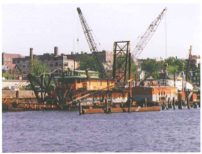
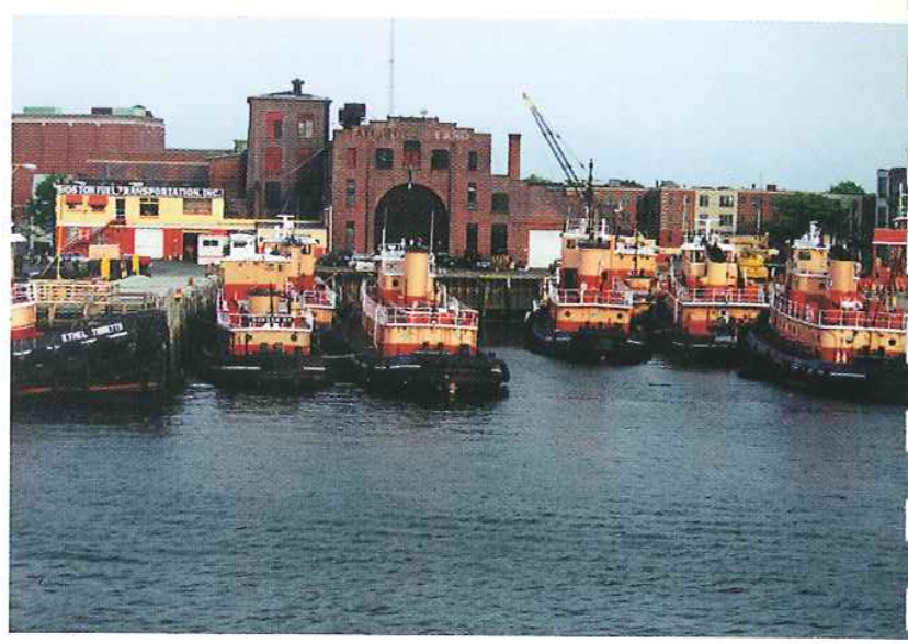
Maritime and industrial use - Maritime and industrial activities have played an important role in the history and development of East Boston. These activities are located primarily along the Inner Harbor waterfront and Chelsea Creek. Some maritimeerelated activities are in decline, as illustrated by the closing of the Hess Oil ’liank site; other maritime service industries such as towboats are still in demand. To promote and maintain the maritime uses, recommenda tions include:
Special attention has been given to open space and the pedestn’an environ ment, as the East Boston community has historically suffered from a lack of open space and inadequate pedestrian access to existing Open space and the waterfront. Creation and reinforcement of Open spaces include attention to the waterfront Open space and Harborwalk, neighborhood open space, streetscape and boulevards, and the Greenway, a network of new or existing adjacent open spaces.
Harborwalk , The creation of pedestrian walkways along the waterfront and expansion of the existing Boston Harborwalk system in East Boston is proposed. Harborwalk is an important element of downtown Bostons water front, of Which the East Bosten waterfront should be a Vital component. Principles which should be used in shaping the East Boston waterfront include:
Waterfront open spaces - Expansion of the waterfront open space network along the Inner Harbor and Chelsea Creek is proposed. These open spaces could be created as an expansion of existing major public spaces, as is planned for Piers Park Phase II at Pier 3. Other open spaces can be created where open land was reserved for this use, such as at the Condor Street Urban Wilds. In addition to this important open space, additional waterfront open spaces could be created as part of mixed-use developments.
East Boston Greenway - Several open spaces are planned as part of the Greenway, including:
Other public space improvements, Several open spaces have been designate ed for improvements by the Boston Parks and Recreation Department including Porzio Park, Noyes Playground and the Pan’s Street Playground. Open spaces or plazas within commercial centers should also be improved. In addition, it is rec0m~ mended that a series of existing trianguu lar interseettons be improved and that upocket park" improvements be included while maintaining parking spaces, as the community desires or as opportunities arise.
Streetscape Improvements Major areas for streetseape improvements have been designated to reinforce the recommene dations 0f the Plan. These include:

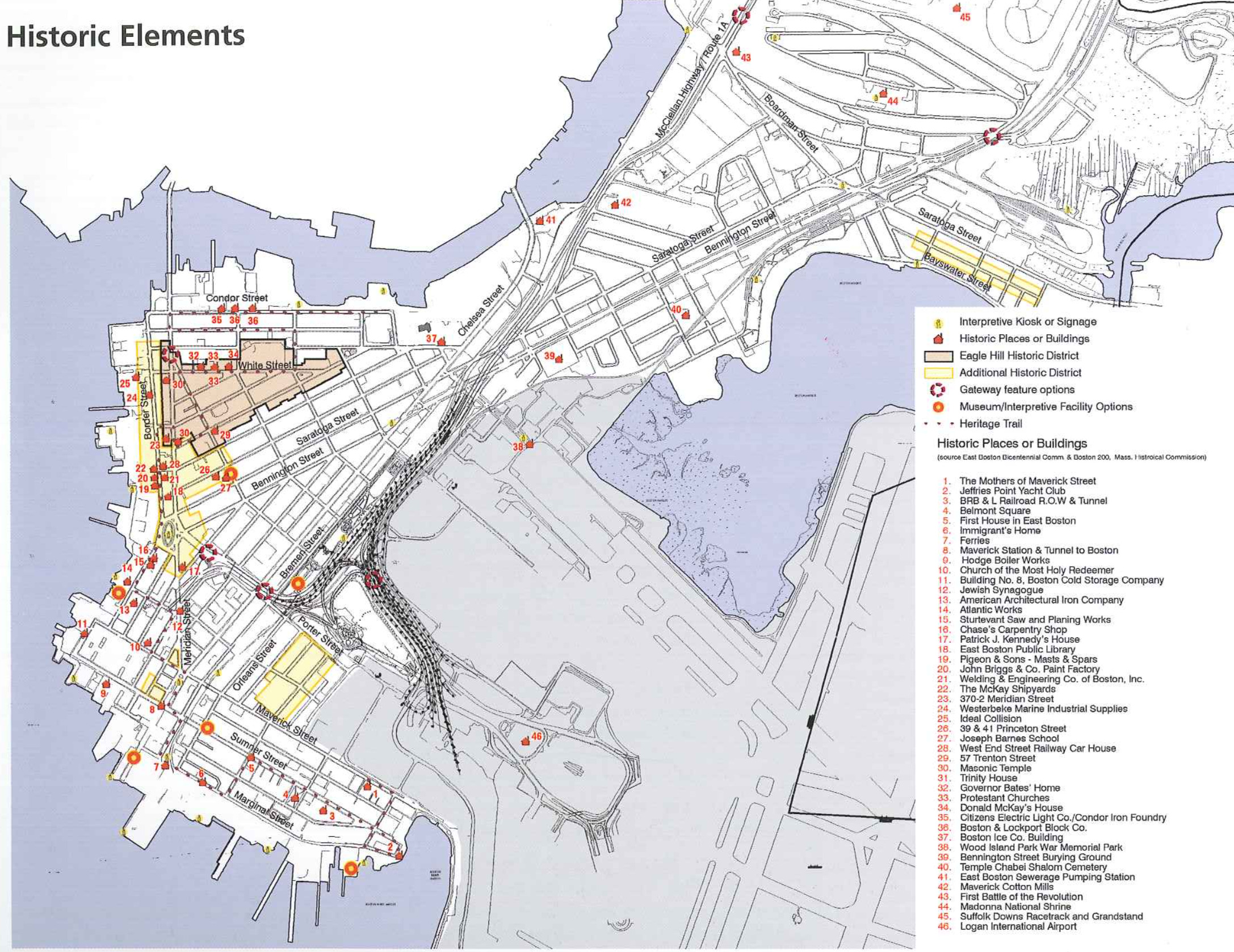
Historic preservation is a key principle under the Plan. An extensive field survey was done by the Boston Landmarks Commission (BLC) in 1989/1990 which documents approximately 6,194 historic stmctures, with several districts recommended [01’ local designation or for listing on the National Register of Historic Plaees. More recently, the Landmarks Commission has completed a survey of East Bostorfs industrial waterfront structures.
The BLC recommendations seek to pre serve and enhance the character of East Bostotfs waterfront and its neighborhoods. The newly-designated Eagle Hill National Register Historic District expands upon a recommendation in the 1989/90 BLC survey. Trinity House, the Donald McKay House, and 39 and 4-1 Princeton Street are designated Boston Landmarks.
Building upon the findings of the BLC survey the Master Plan recommends continued rehabilitation of historic structures and establishment of additional historic districts in neighborhoods and akmg the waterfront, consistent with the Boston Landmarks Commissionk historic surveys and hndings.
East Boston historic features should continue to be inventoried. Creation of a ‘1heritage11 type trail that links the waterfront and neighborhoods’ historic resources throughout East Boston is strongly recommended.

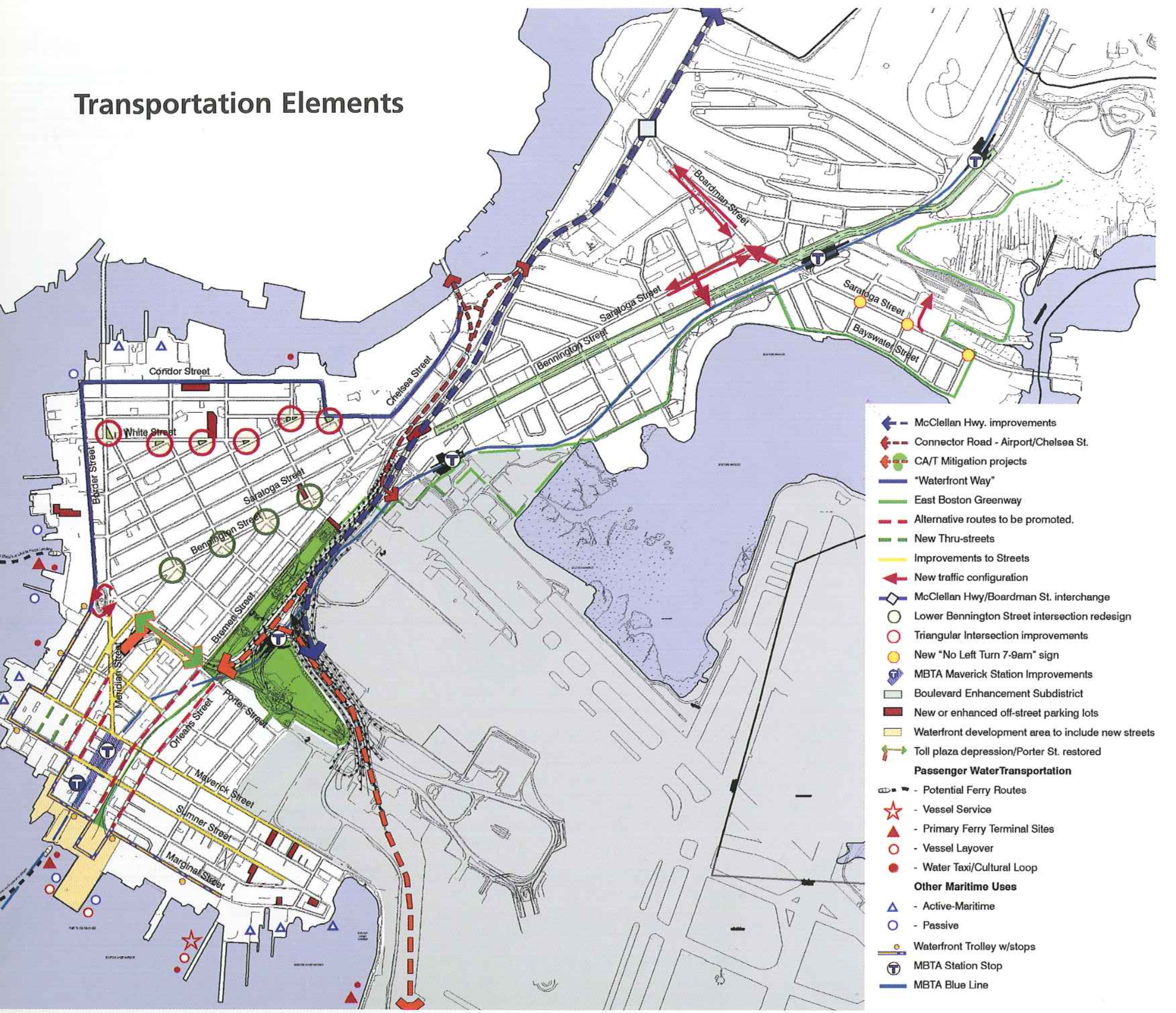
Transportation, parking, and access to other Boston neighborhoods are prominent elements of the quality of life, health, and stability of East Boston. The transportation aspects of the Master Plan must address the needs of all users including pedestrians, ears, truck, buses, and rapid transit, as well as water transportation.
Recommendations include short-term traffiocalming measures and designated truck routes, and lang~term circulation hnprovements such as depression of the tunnel portals, improved parking, water and land public transportation, and designation and improvements of llGateways to East Boston“. East Boston has sacrificed much of the continuity and amenity of its local vehicular and pedestrian circulation system to regional transportation projects. In par ticular, Logan Airport, Route 1A, the Sumner and Callahan Tunnels and the new 122d Williams Tunnel have taken up land, generated truck and automobile traffic, and created physical barriers between neighborhoods and the waterfront. The transportation recommenda~ tions of the Master Plan seek to mitigate the negative impacts of these facilities by stressing pedestrian, transit, and water transportation improvements which provide alternatives to auto travel and restore connectivity between neighe borhoods and open spaces.
Transportation Recomendaticms:
Enhance Sumner Street, Marginal Street, New Street and Border Street in combination with new connecriens through the Clippership Wharf and Pier One development parcels to create a clearly identiliable waterfront boulevard_a uWhy“. The new street will serve as a connector between new residential communities and Central Square.”Wayl’ could also be extended to Condor Street.
Undertake short-term ttalhc-eahn’mg measures to limit airportigenemted and highway by-pass traffic from using the Summer Tunnel access streets (London, Pan’s and Gove), the Logan AitporI/Ted Williams Tunnel access streets Ueffr’tes, Mavenck and Sumner Streets), Day Square, Orient Heights Square, Saratoga and Bayswater Streets, and Condor Street.
Improve Ltaditlonal and new boulevards, especially Bennington Street from the Revere [own line to Central Square.
Develop special treatment at East Boston gateways to Revere, Chelsea and highway ramps to improve the public realm and identtly the neighborhood.
Simplify traffic circulation, facilitate bus movement, provide additional oH-street parke ing, and enhance pedestrian amenity and safety within business districts including Central Square, Day Square, Maven’ck Square and Orient Heights Square.
Designate and sign tmck routes and create a new bypass road from the Chelsea Street Bn’dge and Route 1A to Logan Airport.
Increase the range 0f water transportation options, with expansion capabilities once markets are Seveloped and ridership is established. Promote long-term improvements such as the Urban Ring transit line and depression and relocation of the Sumner/Callahan tunr nel portals.

Based on the market assessment, future economic development would occur within four areas: the waterfront along the Inner Harbor, the residential neighborhoods, the McClellan Highway and Chelsea Creek corridor, and the existing commercial business centers. The development guidance recommendations include:
Buiiding on East Boston’s competitive strengths, including its prom’m’tty to dowry town Boston and Logan International Airport, its waterfront location and facilities, its existing businesses and institutions. its historic structures, and its relative affordabiliqr.
Enhancing the existing residential character of East Boston neighborhoods.
Preserving view corridors, access, and appropriate scale of development along the waterfront
Improving the pedestrian expedence and amenities throughout the community.
Ensuring continued pubiic review of new developments.
Promoting the existing histmic district and other programs to reinforce urban design character of the historic neighborhoods and waterftonts.
East Bostonis development must occur Within the framework of city, state and federal regulatory programs.
In 1993, Article 53 was adopted as part of the Baston Zoning Code and estab lished the East Boston Neighborhood District. Article 53 zoning is generally compatible With the Master Plan goals and elements. One exception is zoning for Bennington Street in the area of Orient Heights Square Where the Master Pkm recommends a change to Corridor Enhancement Sub-District in order to strengthen the boulevard character of Bennington Street.
The Boston Zoning Code contains set:[tons pertaining to waterfront develop ment and other special dism’cts. The regulations pertaining to the waterfront are the most critical to shaping East Bostorfs development future. Chapter 91 Waterways regulations preserve and protect the public rights to filled and Bowed tidelands for uses that are waterdependent or otherwise serve a public purpose, including those waterfront resources classified by the Massachusetts Coastal Zone Management (MCZM) program as Designated Port Areas (DPA). There are two DPAS in East Boston: the Chelsea Creek DPA Which includes a continuous strip of the land along the Chelsea Creek, and the East Boston DPA (Boston Inner Harbor waterfront) Which ’13 made up of [our disconnected parcels.
When the City prepares its Municipal Harbor Plan for East Boston, it will be necessary to evaluate the DPAs in light of their suitability {0r maritime industrial use such as depth of water, character istics of land area adj acent to the wateru front, as well as land based transportation access and available utility service, and other important attributes necesr sary for commercial maritime uses. Consideration will need to be given to neighboring uses and the Master Plan reeemmendations as well as to the allocation of supporting commercial uses Within the MCZM regulatiods limit of 25% of total DPA land area.
The Master Plan is supportive of the goals of Chapter 91 and the MCZM [Designated Port Area regulations. Within this reguiatory environment, the Master Plan promotes additional Open space and access along the waterfront. 1t retains and respects the DPA goal of protecting maritime industrial resources With some modification.
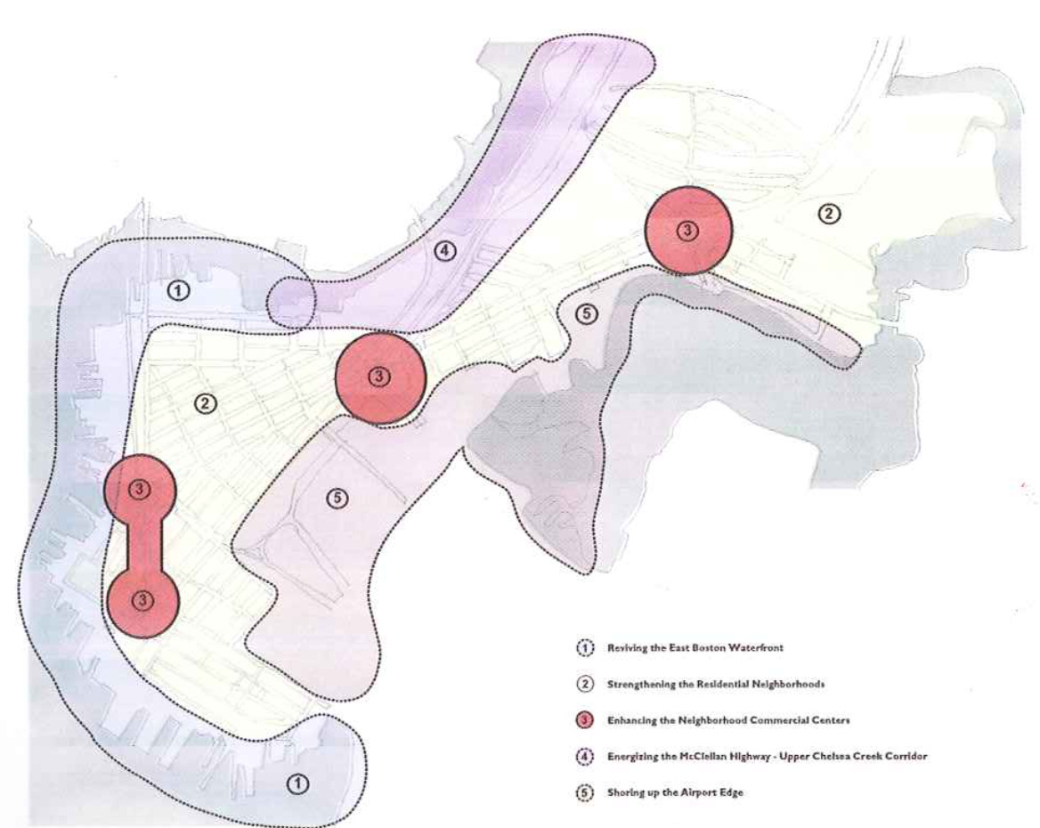
The Plan identifies specific geographic areas of East Boston where change is anticipated. Determination of how these places will develop will be key to the success and quality of life of the East Boston community as a Whole. The section is divided into five subsections, each dedicated to a particular sub-area or focus area.
Each focus area reflects planning analysis developed with the community dun ing the planning process. Each area is accompanied by a description of recommendatians in terms of the six elements of the plan, as applicable: land use, open space and public environment, historic preservation, transportation, development guidance, and regulatory environment.
Reviving the East Boston Waterfront: This focus area encompasses thejeffries Point/Massport waterfront, the Old East Boston waterh’ont, and the lower section of Chelsea Creek bordering Eagle Hilii
Strengthening the Residential Neighborhoods This focus area encompasses all residential neighborhoods including Jefh’ies Point, Eagle Hill, The Flats, Harborvicw, arid Orient Heights.
Enhancing the Neighborhoods’ Commercial Centers: This focus area includes actions and policies recommended in all four major business centers: Maverick Square, Central Square, Day Square, and Orient Heights Square.
Energizing the McClellan Highway - Upper Chelsea Creek Corridor: The indusm’al waterfronL in East BosLon is primarily situaLed in the area along the Chelsea Creek and McClellan Highway. 1L is dominated by industrial and commercial uses that rely on the McClellan Highway forr immediaLe [ruck access, providing major opportunities for economic development in East Boston.
Shoring up the Airport Edge: This focus area includes the various parcels of property which surround Logan Airport. This focus area affects most neighborhoods in East Boston and has opportunities for majcr community open space benefits.

East Bostorfs waterfront is a critical area of focus for the Master Plan. The area offers gTeat development potential, given its views of downtown Boston and Charlestown, its strategic location for maritime activities, and its rich histDIy. Existing and recently proposed development projects 011 the waterfront focus on the Harbor. The communitfs desire for increased open space and cu1~ tural activities must be balanced with the private sector market demand for waterfront residential use and the regional demand for port-related activitles.
Recommendations include regulatory and urban design guidelines intended to protect the public interest in, and access to, these valuable waterfront resources.
Recommendations:
Expand the mix of uses on the waterfront to include additional residentialj retail/commereial and cultural uses coexisting with present marine industrial, residential and institutional USES.
Increase the quality of residential use on the waterfront by building new housing on Pier 1. Clippership Wharf, Boston East and other waterfront properties that become available for redevelopment, while improving Shore Plaza East and other residential uses adjacent to the waterfront.
Promote potential retail and commercial uses at new development sites that complement abutting commercial and retail uses in Mavetick and Central Squares.
Maintain maritime use and maritime port services including those at the Shipyard, along the Inner Harbor waterfront and along Lower Chelsea Creek.
Promote culturaI/institut’tonal uses that reileet the heritage of the community. A eultural foundation should be formed and housed in a temporary facility as a first step toward the creation of a museum on the waterfront. The permanent museum could include exhibits that interpret East Bostonis history and development Summarized in feur basic themes:
The waterfront oHers the best opportunity for the creation of new parks and open space within East Boston.
Recommendations:
Create additional waterfront parks along the Inner Harbor waterfront. Expanding Piers Park by creating additional waterfront park; at Piers 3 and 5 would create a major water from open space with spectacular views of Boston Harbor and downtown Boston. Programming for these two piers is currently at an early stage, but each park offers potene rial for active and passive recreation and would create a continuous landscaped public waterfront park along the Jeffries Point neighborhood.
Develop open spaces along the lower section of Chelsea Creek. The Consdor Street Urban Wilds is being transferred to the City of Boston’s Parks and Recreation Department, which plans to clean it and create a passive recreation park with restored vegetaoon and waterfront access. An additional open space in the form of a pedestrian access corridor to the bulkhead line would be created on a portion of the vacant Hess Oil site and conneceted to the Urban Wilds by a 1,200 foot segment of Harborwalk along Chelsea Creek. The site’s redevelopment will necessitate a major clean up and might be constrained by its location within a Designated Port Area. The abandoned railroad right-of-way at the norther end of East Boston’s Chelsea Creek shoreline may present an additional open space opportunity.
Expand Harborwalk to connect the waterfront open space system and public environment. The existing East Boston Harborwalk, which runs from the Harborside Hyatt Hotel to Porzio Park, should be extended when new parks and new activities are developed on the waterfront. Harborwalk would continue along Marginal Street’s existing and new waterfront park system, threading its way around the proposed Pier 1 and Clippership Wharf developments and connected to LoPresti Park. There are also opportunities to extend Harborwalk from LoPresti park to the Boston East site, the Liberty Plaza (where a small Harbor already exists), Umana Banes School and Shore Plaza East. The route would then turn onto Condor Street along the Chelsea Creek, through the Hess Oil site and up to the proposed Urban Wilds Park.
Create waterfront pocket parks and public access. In connection with future redeelopment at Pier 1, Clippership WharL Boston East, Hess Oil, and the Car Barn site, small pocket parks and public access rightiofrways would be an integral part of the site design.
Upgrade existing public waterfront open space Public spaces such as Porzio Park, LoPresti Park, and the Umana Barnes School property should be enhanced to be part of a cohesive waterfront open space network.
Facilitate public access and use of the water front. Privately owned waterfront properties where waterfront space is unused, such as Liberty Plaza, Shore Plaza East, and Hodge Boiler Works, present opportunities to C0117 tinue Harborwalk.
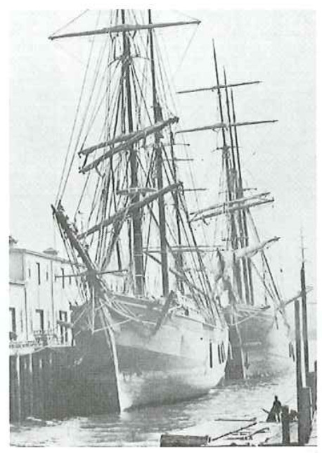
East Boston was initially planned to contain a mix of homes, maritime and other industries, and recreational facilities. By 1839, East Boston was already an important waterfront industrial center, with shipyards specializing in the construction of Clipper ships. East Easton’s Wharves served as Bostorfs center for grain exports to Europe as well as the Boston terminal for the Landon-based Cunard ship line. Waterfront structures and features reflective of this heritage still remain. The Boston Landmarks Commission recently undertook an inventory Of the Old East Boston waterfmnt and Lower Chelsea Creek waterfront and identified a number of significant structures. This existing industrial character of the waterfront is part of the quality of Me and unique character of East Boston.
Recommendations:
Undertaking projects designed to illustrate East Busteds rich history. These could range from historic markets and exhibit panels mounted along Harborwalk, to interpretive landscapes designed to be integrated into the waterfront park system, to a cultural waterfront facility such 35 a museum with community space and exhibits, modeled after the EMS North End Historic Piers program.
Establishing historic districts to include the contiguous waterfront area where the density of historic man’tlme features and waterfront integrity is high.
Adopting historic waterfront guidelines that would not only protect signiftcant structures but would also ensure the contextual respect fulness of new development.
Transportation recommendations are centered around strengthening pedestrian and vehicular circulation along, to, and [tom the water in conjunction With development or redevelopment of key parcels such as Pier 1 and Clippership Wharf
Recommendations:
Designate a continuous uWaterfront Way, with a signature streetscape treatment along existing streets and new sections created within and between the development parcels.
Create a continuous pedestrian system linking the Greenway [.0 I’Iarborwaik (including passage through the shipyard). Provide additional landings for water transiportation services.
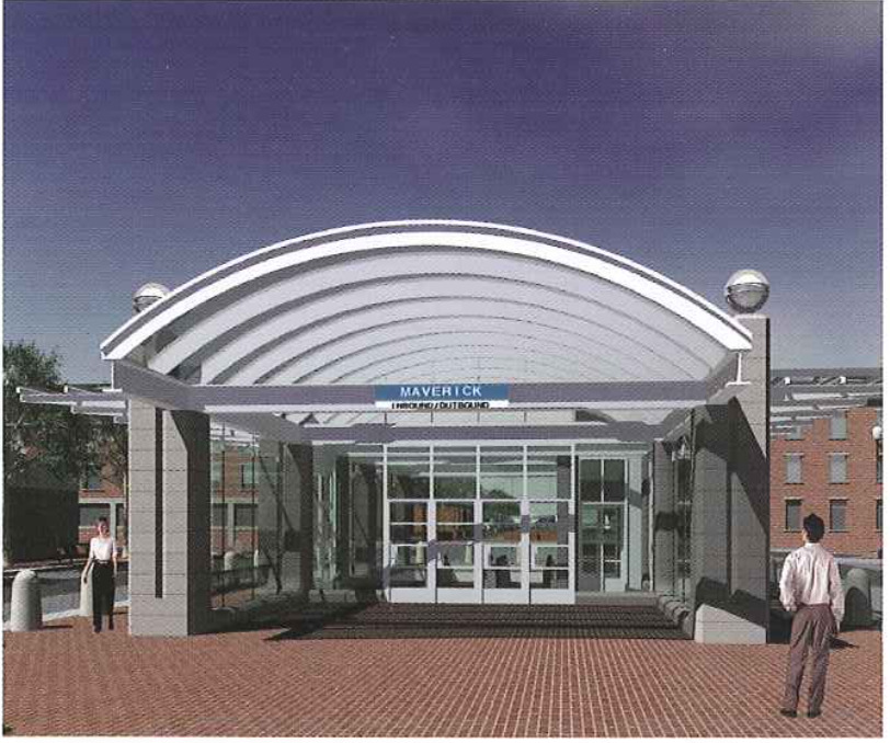
Develop a new Maverick Station headhouse closer to the water once development is completed at Clippetship Wharf.
Abutter access to development parcels 0n Bremen Street and Havre Street should be promoted to encourage use of these streets for traffic resulting from new development, and thereby reducing trafftc impacm on Orleans Street, Maverick Square, and Meridian Street. Higher residential densities should be planned in the areas closest to the Blue Line stations and water transportation landings; parking requiremens should be tailored to 3.1le for a lower ratio of spaces to dwelling units in areas closest to transit.
Detailed traffic impact studies need to be completed for each development site as part of the city and state environmental approval processes. But prelimi~ nary analysis of likely land uses and densities for the existing and new activities along the waterfront indicate that traffic can be accommodated without undue negative impacts on existing residential areas.
Recommendations:
Create an additional street system to support vehicular access and traffic When dcvelOPing Recommendations: This section describes key develop larger waterfront parcels such as Pier 1 and Clippership Wharf.
Integrate a new street system while developing contiguous large parcels to allow for improved vehicular flow.
Connect a new street pattern to the existing East Boston street system to preserve public use of and access to the waterfront.
Encourage use of alternative routes to divert vehicles from the congested Maverick Square and Meridian Street.
Develop and maximize use of nonrauto modes of transportation including water shuttles, bicycles, Walking, buses, a waterfront trolley, and the Blue Line.
Strengthen pedestnan connections to the multiemoclal transportation center in Maverick Square. A new pedestrian entrance to the station on the waterside of Sumner Street should be created, and extra peak hour service should he added on the Blue Line to turn trains around at Maven’ck Square as development intensifies in this area. This will help insure that riders boarding at this station can be comfortably accommodated.
Allow on-street parking on new streets.
Create a connected pedestrian circulation system along Harhorwalk, the Greenway, and connecting streets and sidewalks.
Upgrade the existing waterlront street network [torn Marginal Street to Condor Street_designated East Bostonis “Wateii’ront Way: with a signature streerscape design.
Recommendations:
Provide water transportation facilities (such as public ferry terminals for scheduled services, water taxi/cultural loop, and charter use) at key sites along the waterfront including the expanded Logan South, existing Lewis Mall. and a new terminal at the Liberty Plaza/Central Square waterfront.
Commuter shuttle services with associated landside improvements to facilitate access and passenger dropeoIE/pickeup may be added from Lewis Mall and Liberty Plaza Once an adequate volume of ridership is established. At present, demand levels are too low to make such services and improvements.
Create additional space for public landings for small vessels at ferry terminals.
Develop clocks and landings for water taxis and small boats at seveml exisLing and new locations. Existing Clocks with low free" boards are located at Boston Marine Shipyard and at the Piers Park sailing center. Additional sites may be added as part of new development at Clippership Wharf, Boston East site, and at the META Car Barn site on Chelsea Creek Such docks would provide a touch-and-go landings for smaller private and ment Site guidelines for the Masspott Piers, Boston East, Liberty Plaza, Hess Oil, and overall waterfront development guidance. commercial vessels.
Allow space for vessel support services (parriculai’ly ship repair and maintenance service es) and layover berthing along the waterfront at a variety of East Boston pier sites would add incrementally to the East Boston economy by providing maritime employment.
This section describes key development site guidelnes for the Massport Piers, Boston East, Liberty Plaza, Hess Oil and overall waterfront development guidance.
Recommendations:
Maintain view corridors to the water along Marginal Street, Clippership Lane, Lewis Mall, Bremen and Orleans Streets, and the Greenway.
Maximize views by designating Harborwalk to be barrier-free, limiting fences only for safety reasons, and creating structures and shelters which are transparent and screenlike.
Develop unified and unique lighting and sigr nage consistent with l-iarborwalk and water Front street frontage which celebrate East Boston’s waterltont heritage.
Create building blocks compatible in scale and character with the waterFront and adja~ cent neighborhoods.
Make street access as an extension of the existing street pattern.
Minimize trallie impact by orienting drive~ ways for parking in line with Havre or London Streets, which should be improved to allow for increased vehicular use.
Screen and landscape undesirable uses (such as surface utilities, parking lots. and/or parks ing garages) with trees, shrubs, and other plantings. Parking garages should include street level retail [rontage and other public spaces.
Respect setbacks at the edge of the water, which would include designing plazas or parks with street furniture and landscaping consistent With Harhorwalk standards, taldng advantage of the waterfront views.
Provide municipal services when developing larger parcels. The developer should address additional city service needs such as fire, police, schools, etc.
To a large extent, the recommendations for the East Boston waterfront respect and conform to the existing eiLy and state regulatory framework for tidelands and waterfront uses. New developments such as the Massport Piers Project and Clippership Wharf will have to comply with the states Chapter 91 regulations and the City zoning regula tions for Tideland and Waterfront Districts. The major principles of these two regulatory programs are:
Provide for public access to and along the waterfront through extension and enhance, ment of Harborwalk and creation of new public open spaces.
Require proper public purpose of projects Within tidelands including conserving the capacity for water-dependent use through such measures as height and setback limits.
Preserve maritime industrial uses within the Designated Port Areas.
Continue and promote port service activities along the Inner Harbor.
Provide water transportation facilities.
The Master Plan includes recommendations for two waterfront sites which may require modification to a section of the Designated Port Areas (DPA).
The Boston East site is partially located within DPA at the north and south ends of the parcel. The Plan recommends housing development on this parcel, which would require removal of the Designated Port Area (DPA) Classification. T here are several reasons why removal of the DPA on the parcel should occur. First, the nonsDPA C611" ter portion of the site makes it difficult to View the parcel as a cohesive planning unit The City owns this parcel but not the abutting parcels. The divided nature of the parcel would make it difficult to have an on-going maritime industrial use when considered in rela tion to other conditions affecting the site that have contributed to its current vacancy. Border Street provides inades quate truck access to the site for DPA uses. The waterside infrastructure is so dilapidated that the City is planning to use Seaport Bond funds to remove the derelict piers. Repair and improvement of the piers is not eost-effeetive for maritime industrial use. The parcel is zoned as Waterfront Commercial, which allows multi~ dwelling residential uses on the second story and above with conditional use on the first floor and basement.
The Hess Oil Site on Condor Street and Chelsea Creek is located within the Chelsea Creek Designated Port Area as well as the Maritime Economic Reserve (MER) Subdistn’ct under Bostonis Zoning Code. There is strong community support toward using this parcel as Open space. This use would also require removal of the site from the Designated Port Area. Such a Change, however, may be very difficult to implement since this site is large enough for backland operations, has good truck access, and is located at a shipping channel where large public sector capital investments are underway to improve its capacity, including dredging and reconstruction of the Chelsea Street Bridge. The current MER zoning uses are focused on water-dependent indus trial uses. Open space uses are not allowed and would therefore require a zoning Change. This site could, however, be reserved for environmentally come patible industrial uses while allowing landscaped pedestrian access to the bulkhead line within DPA regulations.
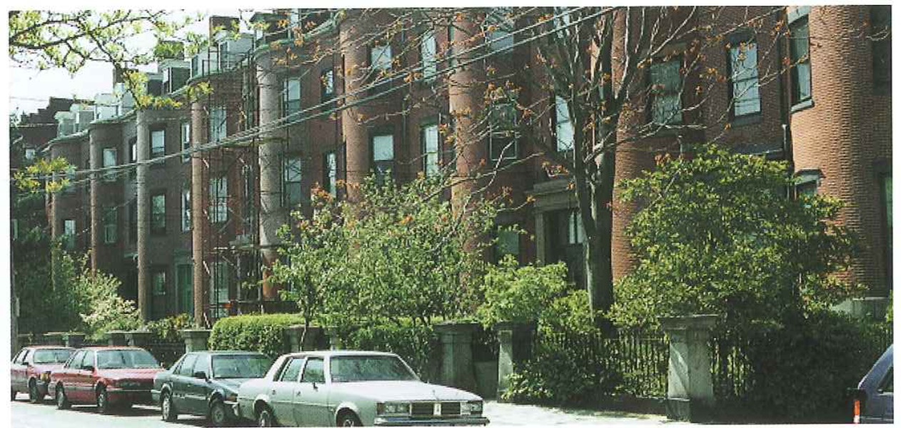
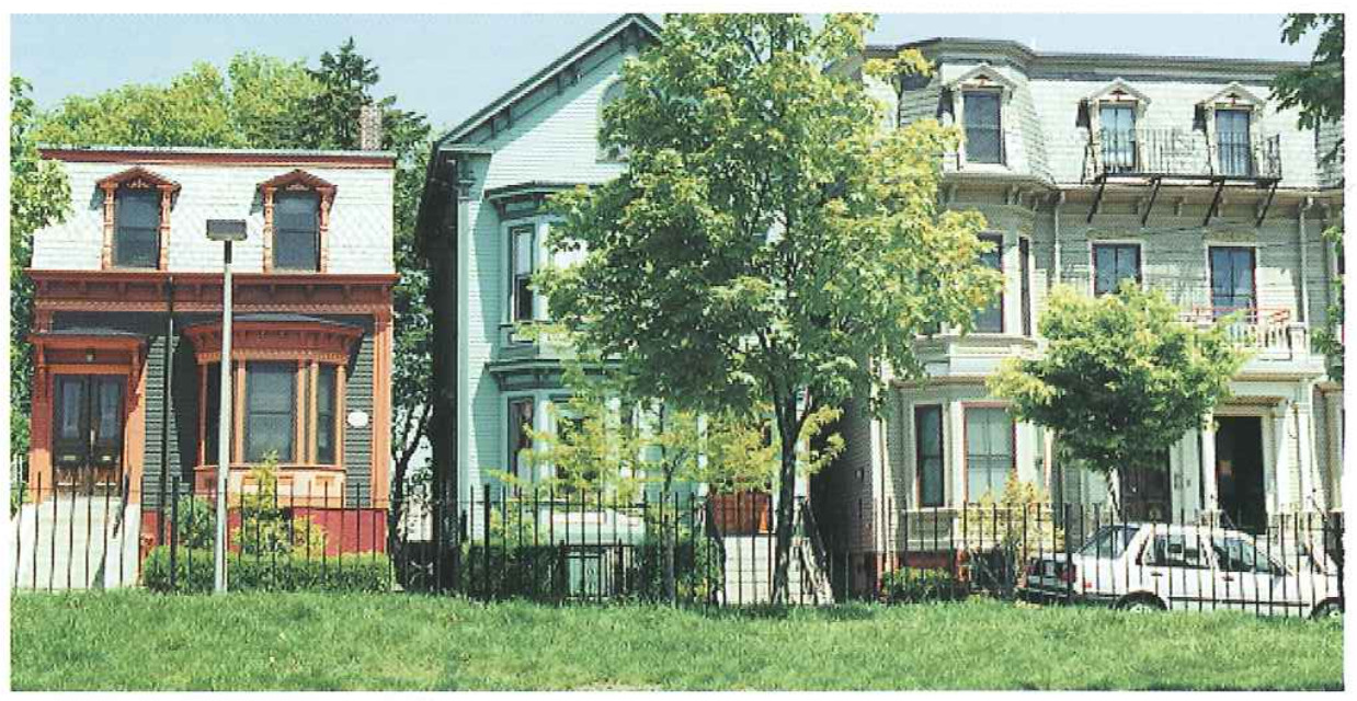
East Boston was one of the earliest planned communities, and its residential neighborhoods are the direct result of 19th century urban planning. The different residential neighborhoods are unique, yet have similar issues to be studied. Some of the key issues are the preservation of residential character, the development of connections to the waterfront and Harbor, and the mitigation of impacts from waterfront and other development.
This Master Plan makes recommendations for smaller scale housing and commercial development throughout the community, as well as the creation of additional buffer areas to protect residential neighborhoods from adjacent development sites and the Airport.
East Boston neighborhoods are stable, with a high rate of homeownership despite Chang" ing demographics. Residential areas have continued to increased in value in line with curTent economic prosperity. Thus, land uses within residential neighborhoods have undergone little change. The future of East Boston neighborhoods should not be clever;tated by major land use changes for new development, but upon the minor land use changes to protect the existing quality of life.
Recommendations:
Protect residential neighborhoods, particularly Harborview and Oiient Heights, from expanding commercial uses, especially autoidependent activi ties along Bennington Street.
Promote the development of landscaped Ofl-street parking lam within vacant lots in Eagle Hill and JefFries Point.
Upgrade properties where open space areas and/ot community gardens could be created. which would add desired gteen space within dense residential areas.
Increase the residential base west of Meridian Street by developing residential units such as artists! live/work spaces near the Boston East site as part of a strategy to diversify land uses near the waterfront and the Meridian Street corridor. Redesign Maverick Gardens as a major public/ptivale redevelopment venture to reduce density, improve physical image, and unite the project with the surrounding neighborhood.
Review potential school siting opportunities in light of the Cityls new policy favoring the establishment of llwalloto" schools. This may make prevle ously infeasible options such as reuse of the his~ toxic: Umana Bames School viable, as major bus access would not be required.
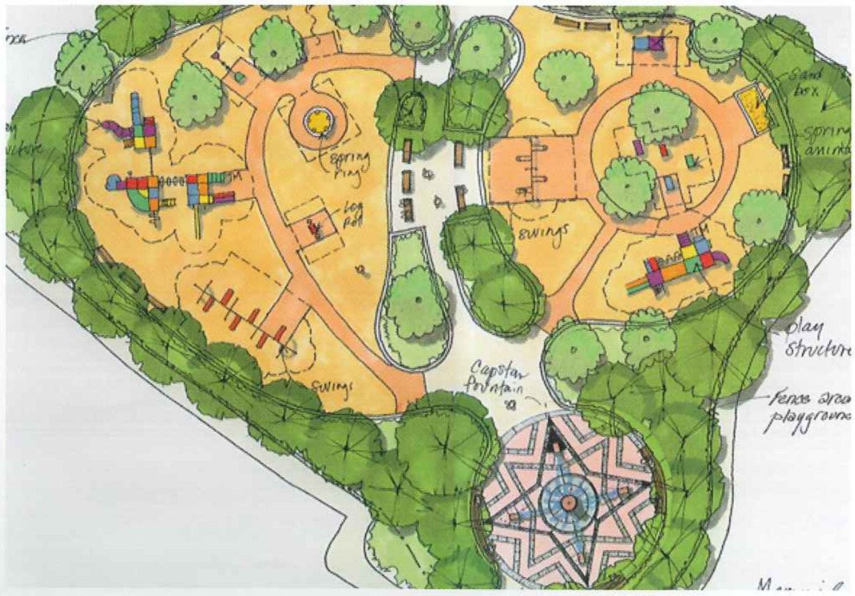
Analysis of neighborhood open Space in Boston indicates that East Boston ranks low in open space acreage per capita among Boston neighborhoods. This situation is changing as a result of the many open space initiatives currently under? way that will bling East Boston closer to the City average. The Greenway will add 15 acres of open space. Additional open space acreage also will be constructed with the opening of Piers Park Phase II at Pier Three (3.5 acres), Pier Five (1.5 acres), Bremen Street Park (13 acres), Memmial Stadium Improvements (2 acres), and the Condor Street Urban Wilds (8 acres). In addition, public enviv ronment improvements are planned for various areas that have long needed to be physically enhanced, such as the Airport Edge Buffer Program areas in the North and Southwest service areas, Maverick Square, the Main Streets Program with; in Central and Maverick Squares, the Golden Stairs, and Maverick Gardens. Belle Isle Marsh, 139 acres of open space with trails and signage, is a unique and valuable cemmunity resource that Will become more accessible via the Greenway.
Most major Open space additions are recommended as part of waterfront development or M project mitigation. However, East Bostotfs neighbor hoods would be improved with strategic recommendations toward increasing and enhancing green space. To sustain the traditional residential character of East Boston, new open space should be created, and neglected public realm zones should be enhanced to better connect the unique urban fabric.
Recommendations:
Promote a pedestrian connection within the Southwest Service Area com’dur. from Maverick Street to Memorial Park, as; part of the Airport Edge BuEfer Program.
Locate opportunities For off-street, residential parking iots, to replace existing middle-nftheistreet parking at van’tms triangular intersections, and create small public pEazas at these intersections.
Redesign intersections in the lower portion of Benningtnn Street in Eagle Hill with extended sidewalks and additional street trees. This densely populated area contains heavy pedestrian activity, thus improvements to the pedestrian zone along this street would create a more attractive corridor.
Improve streetscapes by consolidating curb cuts, adding street trees, and utilizing signage promoting commerce in Orient Heights, particularly south of Orient Heights Square. The renovation of Constitution Beach and its pedestrian bridge over the Blue Line to Bennington Street would beneht From an enhanced pedestrian environment.
Reopen pedestrian ways or streets through the Maverick Gardens development to allow for better pedestrian and vehicular access, and to restore sight lines hum London and Border Streets to the water.
Locate a major gateway element near the toll/tunnel entry, which Would be part of a Porter Street/Centtal Square beautification initiative. In the event of a major redesign of the to11/tunnel portal area, the location of a gateway element should occur prim to the entry into the tunnel.
Construct attractive signage along the McClellan HighwayfRoute 1A corridor welcoming travels ’tO Boston, and directing people to special East Boston places such as Constitution Beach at the Boardman Street exit or Day Square at the Bremen Street exit.
Enhance the entry to the neighborhood via Bennington Street by reconstructing the thorr oughfare in accordance with the City’s Boulevards Initiative, with a properlyiscaled, treeghned, landscaped quality that is maintainahle, long-lasting, and adapted to harsh urban conditions.
Promote a pedesnian/bieyele connection between the BIFCO site adjacent to Belle Isle Marsh and Winthrop, using the remains of the farmer Belle Isle Bridge.
Create a unique civic design element upon entry from Winthrop via Saratoga Street which could be tied into the East Boston Greenway, that crosses Satatoga Street from the Bayswater neighborhood into the Belle Isle Marsh,
Include public art in new deveiopmehts and public realm improvements.
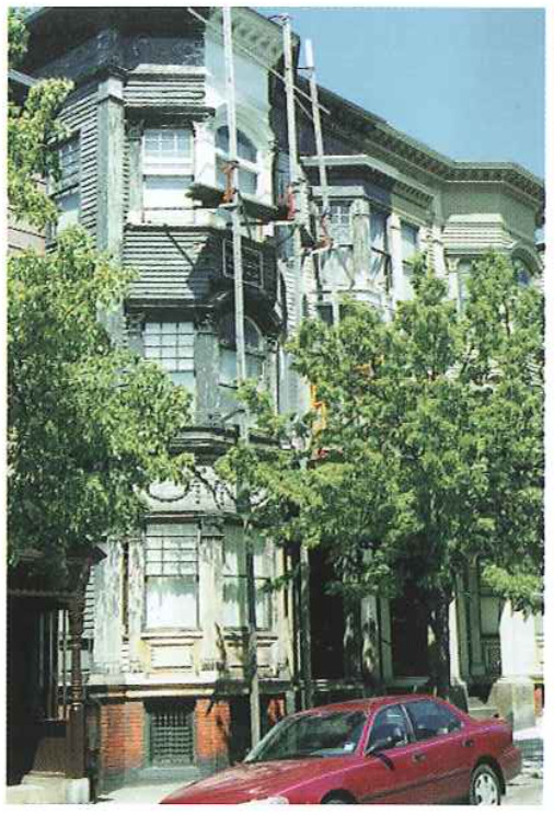
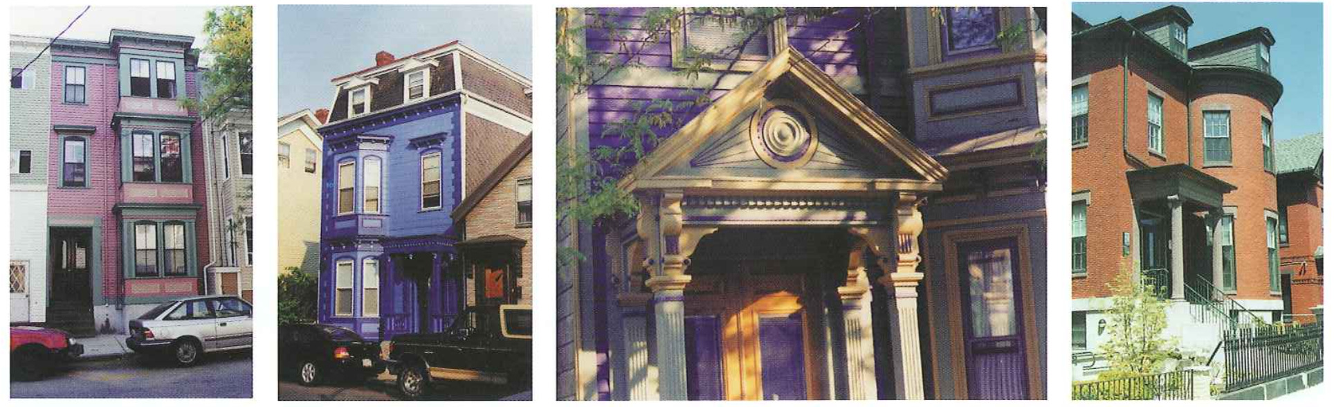
The history of East Boston neighborhoods is reflected in the Victorian era houses which dot Eagle Hillis Historic District and other residential areas. The unheralded battles of the American Revolution, the landfill of five islands over time to form one East Boston, the taking of Wood Island Park (designed by Frederick Law Olmsted), the achievements of past war veterans, and the spirit of past community activists Who fought for East Boston are just a few of the less obvious historic events Which have shaped the heritage of East Boston neighborhoods and should be celebrated.
Recommendations:
Continue tecogniticn and protection of historic landmarks among East Bostmfs [radii tional buildings and districts, as identified by the Boston Landmark? Commission and the Boston 400 inventory.
Devise a “heritage trail”, celebrating sites, events, and people, that links selected his) torie sites and districts to commercial and transit nodes and the waterfront in an effort to guide the historic East Boston experience.
Utilize outdoor interpretive signage that illustrates the historical significance of East Bostorfs treasures, such as an interpretative kiosk atop Madonna Hill depicting the develr opment of Orient Heights and the role of Chelsea Creek in the American Revolution.

The transportation problems canfronting East Boston’s neighborhoods are common to those of other Boston residential communities. Inadequate parking, noise and congestion from trucks, and general traffic are the biggest concerns identified by community residents. Parking is under increased scrutiny due to the proposed influx of new housing units near the waterfront as well as increased in-[ili housing Within the neighborhoods. Truck traffic is an on-going problem due to East Bostonis immediate pTOXimity to Logan Airport and the regional highways. Traffic problems within East Boston are mostly the result of particue lat street configurations and commuter rush huur circulation patterns.
Recommendations:
Continue street improvements for Hawe SLreeL at Meridian Street as part of the East Boston Main Streets program, which has already made some streelscape improvements and impiemented some geometiic changes at acute angle inLersections with Meridian Street. These improvements have worked well.
Enforce the measure which closes the Massport gate aLJeffries Street to all but local residents from 3-6 PM. This has been one mechanism for preventing cut-thtc ugh ttafiie from accessing the Ted Williams Tunnel through Jeffn’es Point.
Create a new connector road that would use the unused railroad embankment to provide a connection for truck traffic from Lhe Airport to the Chelsea Street Bridge Bnarclman Street, and Route 1A without any Ltavel on local streets.
Make Maverlck Street an llollicial" two-way street between Chelsea and Meridian Streets, helping to improve safety and clarify an ambiguous trafhc pattern.
Limit through trafllc bypassing Saratoga Street east of Orient Heights Square on Bayswarer Street and Goldsmr Street by posting “No Left Turn 7-9 AMn signs on westbound Saratoga at Annavoy Street, Teragram Street, and Shawsheen Road.
Develop vacant lots in neighborhoods as resident parldng lots to minimize on-srreet parking demand. Neighborhood parking with landscaping should be promoted as a potene rial reuse for vacant city-owned parcels available for redevelopment through the Department of Neighborhood Development Real Estate Disposition Initiative program.
Seek additional residential parking opportunities in new public facilities by worldng with the Department of Neighborhood Development.
Improve existing parking lots as well as improving public access to them,
Identify existing parking lots for split-user (day/night) opportunities. Split-uset or shared parking at sites such as Eagle Hill, East Boston High School, the Kennedy School, and Day Square would create more Spaces during peak demand hours for a see endary user, which would occur during none peak primary user hours.
Initiate a comprehensive [tame study for Jeffties Point to reHect changed conditions resulting from watetfront development at Massporfs Piers Project and Clippership Wharf.
East Bostonls residential neighborhoods have a distinct urban character. The amount of developable land within the neighborhoods Ls limited. On average, recent new development Within the neighborhoods has come in the [01m of rehabilitated housing, open space improvements, or off-street parking. As new development occurs, controls are needed to ensure that the quality of life of existing residents is not diminished. While proposed projects must go through the mandatory design review process, the Master Plan emphasizes several points Which the community has stressed.
Emulate the scale and bulk of adjacent resi dential structures.
Seek oflestreet parking opportunities.
Screen adjacent neighborhoods with landscaped buffers in the event of larger develop ments on Suffolk Downs and along McClellan Highway.
Recommendations:
Maintain street grid and circulation patterns.
Eliminate structures which block important view corridors.
The Master Plan recommendations would not require any changes to the existing zoning code, which provides an effective regulatory framework. There are no federal OT state regulatory issues relative to the neighborhood recomn mendations.
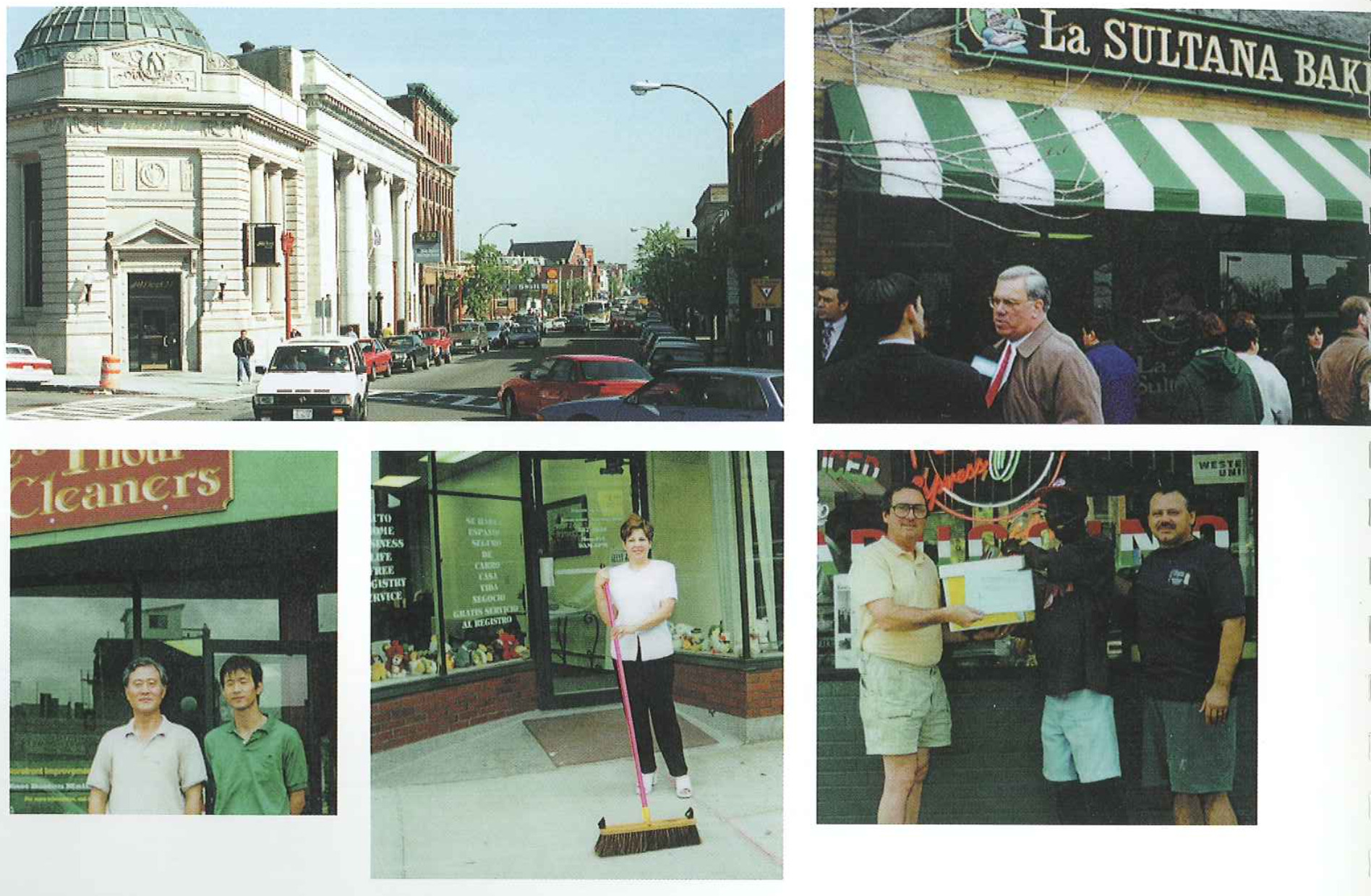
The commercial centers of East Boston are the nodes of daily activity Which help give the community an authentic urban character. The retail environment ranges from small ethnic markets and convenience stores to destination restaurant establishments and regional chains. The market from which East Bostonis retail establishments draw leads the nature of commerce to be more neighborhood service oriented. These centers rely upon the immediate residential neighborhoods for the bulk of their eustomer base. As demographics change within the neighborhoods, the commercial activity evolves as well. With the recent influx of the Asian and Latino populations, retail services have reflected changing needs. New development of residential units would most likely key a slight evolution in these COHP mereial centers to reflect these needs.
However, the scale and character should remain as a series of “main streets” and transit nodes With pedestrian scale commercial spaces.
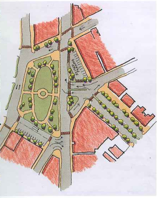
Maverick Square is the primary southern gateway to East Boston and is directly accesssible from downtown Boston by META train and the Sumner Tunnel. Central Square is the core commercial and retail area of the community and includes Liberty Plaza. It is lOCated on the edge of the Inner Harbor. Day Square is the central gateway to East Boston. It is directly accessible from Chelsea and the north through McClellan Highway/Route 1A and the Chelsea Street Bridge. Orient Heights Square is the northernmost business district and. serves the Harborview and Orient Heights neighborhoods.
The commercial centers have historically supported smaller scale retail establishments, except for the Shaws Supermarket at Liberty Plaza Which is a regional store. The come mercial centers provide opportunities for local residents to establish businesses, product diversification, and mixed-use commercial and residential infill and renovation. Nearby residential developments rely on the commercial centers to provide basic services and unique retail activity.
Recommendations:
Renovate existing structures and create inlili mixed-use development combining commercial/retail with semnd-stm’y Office or residential uses within Maveiick, Central, and Day Squares.
Improve the design of Liberty Plaza to reorient some retail opportunities, allow for waterfront views and access, and enhance Central Square.
Whether as a major transit node at Maverick Square or as a major shopping node at Central Square, the squares are places where East Boston residents congregate and interact. Open space and public environment improvements are needed Within all the squares. The squares are pedestrian on’ented and any streetscape improvement should further that characteristic. Street trees, lighting, erosswalks, expanded sidewalks, and signage are all charactettstics that should be accounted for when analyzing the squares for public envi ronment improvements.
Recommendations:
Design infill development at Maverick and Central Square to shore up blighted space along the street wall.
Widen sidewalks, shorten crosswalks and improve peclestn’au safety as part of transportation improvements in Central Square.
Increase street trees as a part of a beautificae tion effort at Day Square.
Create pleasant outdoor cafe environments in sections of each square using landscaped sidewalks with trees and benches.
Reduce the length of the crosswalk of Saratoga Street at Bennington Street to improve the pedestrian circulation as part of planned transportation improvements in Orient Heights Square. Streetscape improvements within this project should be made to improve pavement features, landscaping, distinctive lighting, and street Furniture.
Connect Constitution Beach and the Greenway to Noyes Playground and Orient Heights by improving the streetscape ele ments along Remington Street near Saratoga Street, allowing for better pedestrian circula tion.
The history of the commercial centers in East Boston is an important part of the development of this unique part of Boston. While historically significant buildings are typically not prominent features of the squares, the histon’c role and scale of these commercial centers are hnportant elements to preserve. Furthermore, as efforts begin along the waterfront to highlight its history, the commercial centers would offer add} tional points of interest as part of a Heritage Trail.
Recommendations:
Preserve the role of commercial centers as pedestrian friendly, accessible, diverse neighborhood sewice centers.
Enhance the historic neighborhood scale by upgrading pedesn’lan scale elements such as lighting, special pavement, signage, facade treatments, and other elements outlined within Lhe Main Streem Program,
Integrate the squares as part of a future Heritage Trail which would highlight key hi5ton’c buildings and places in and around East Boston.
The issue of transportation is the most discussed topic among business owners and residents regarding commercial centers. Street configurations, streetscape elements, traffic public transit, and parking are problems which need to be resolved Within the Master Plan. Daily commerce and residential activity require an efficient and viable transportation network within the squares. Traffic improvements will occur at Maverick and Orient Heights Square as part of the Blue Line Modernization Program.
Recommendations:
Improve traffic and pedestrian circulation in Central Square. Maintain Border Street and Meridian Street as two-way, but Saratoga Street, between Meridian and Border Streets, would be made one way westbound and llSouth Central Square" would be made one way eastbound, establishing a counterclockwise circulation pattern.
Reorient the Kennedy School parking lot to have Frontage on Prescott Street, promoting usereshared parking; school use during the clay and Day Square customer use in the evening and weekends.
Enhance the appearance and double the capacity of the existing parking lot at Bremen Street and Prescott Street which is used currently for customers and employees of the Square, but in the future will have increased demand from Bremen Street Park users.
Improve the appearance and secutity of the parking lot under the McClellan Highway along Bennington Street to encourage parking by Day Square employees, freeing up spaces within the Square.
Upgrade pedestrian crossings at Neptune Road/Chelsea Street and Bennington Street crossings at Wood Island Station are also desirable.
Improve circulation and on-street parking at Orient Heights Square. Community groups BIB meeting with the Boston Transportation Department to develop a plan which will improve safety, 510W traflie speeds, and simplify circulation, while discouraging bypass traffic on local residential streets.
Create a summer trolley service, tying Central to Maveliek Square and watetfront parks. Trolley service would also help relieve parldng demands created by park users
Establish a Neighborhood Transportation Association with the ERA and BTD to help lincl ways to meet transportation and parking needs in the neighborhood. Ln addition to neighborhood representatives, the NTA would include representation of other stakeholders, such as local businesses, the Main Streets Progtam, Massport, the META, the Boston Housing Authotity, airport businesses, waterFront industties, and developers of proposed projects.
The traditional role of East Boston commerce will remain as development occurs because of the unique geographic and market orientation of East Boston. As commercial space becomes available, efforts should be undertaken to attract businesses which would succeed within this retail environment. The community is becoming more ethr nically diverse, and waterfront residenu rial development will bring additional cash flow to these centers.
Recommendations:
Attract traditional neighborhood businesses with a marketing initiative that outlines the benefits of the East Boston market.
Extend the Main Streets program from the Central SquareAMeiidiau Street-Maverick Square conidor to Day Square and Orient Heights Square, which would help existing businesses formulate marketing goals and enhance the retail environment within East Boston
Increase retail supply as development of waterfront housing occurs to take advantage ol this new market
Encourage training and technical assistance for local residents to and them in becoming the new retailers in an enhanced commercial economy.
City zoning is the primary regulatory tool applicable to the commercial centers.
Recommendations:
Neighborhood Services vs. Community Commercial designations - The current zoning reflects the communityls input on differentiating controls in Central Square From the other neighborhoocl centers.
Guide retail to ensure continued concentratetion within existing commercial centers.
Enhance travel corridors to strengthen the commercial disttictsi links visually and functionally.
New industrial or commercial development in this area would be largeuseale and could provide employment oppotn tunities for local residents. The lack of residential neighborhoods adjacent to this area of the waterfront makes industIial uses more feasible. Furthermore, since nearly all of the East Boston parcels along the Chelsea Creek are Designated Port Areas under Massachusetts Coastal Zone Management and Chapter 91 regulation, certain usesfsuch as residential and recreational_would be strictly prohibitecl.
Current land uses Within this corridor are mostly commercial with some industrial uses. These existing commerw cial and industrial activities are mostly oriented toward the airport or the water port. As long as the airport remains, the demand for commercial and industtial uses associated with the airport will exist Within the McClellan Highway corridor. In addition, planned transportation improvements to McClellan Highway Will increase its appeal for large scale commercial/industrial uses.
Recommendations:
Support and increase cornmercial/iudustrial uses in this area to generate significant positive economic benefits for the community in the form of additional jobs and taxes.
Open space in this cortidor currently exists only at Madonna Hill, which is designated as an Urban Wilds. As a regional commercial and industrial core rider, demand for open space does not exist Within this area of East Boston. Pedestrian and vehicular eonlliets are Obvious, and must be addressed if plans to widen McClellan Highway come to fruition. However, public environment improvements should be made to buffer residential areas from major develop ment sites and future open space eon; nections should be reserved Within the corridor.
Recommendations:
Secure the sloped. landscape at Madonna Hill to eliminate Further erosion. Upgrade the existing park at the end of the intersection atop the hill to include better landscap~ ing and Observation areas.
Establish a landseape buffer between Waldemar Street and the Suffolk Downs access drive off McClellan Highway to protect the Orient Heights residential neighborhood from potential redevelopment of the Suffolk Downs site.
Extend the Greenway along the abandoned railroad rightiofiway.
The history of Chelsea Creek has gone untold for years. This important waterway has played a role in battles of the Amenean Revolution and the development of adjacent ecmmunities. The history of the Chelsea Creek is evident within the Eagle Hill section of the Creek. This is an opportunity for the community to create a unique setting to illustrate the heritage of the Chelsea Creek.
Recommendation:
Place an interpretive kiosk atop Madonna Hill to illustrate the local history and natural environment.
McClellan Highway is the neighborhoodjs most traveled thoroughfare, with most (if the traffic travelling to and from the airport or downtown. In an effort to minimize negative impacts from regional traffic, plans to produce a more efficient highway should be pursued. Commercial and industrial activities will most likely dominate the land uses along this corridor, due to its proximity to the regional highway system, Logan Airport, and the North Shore. Thus, transportation impruvements Should be directed to alleviate negative impacts of the highway on the community and facilitate the highest and best uses along the corridor, Which are commercial and industn’al activities.
Recommendations:
Create a new Connector Road (as described above) in the railroad cut which parallels McClellan Highway in the vicinity of the Route 1A on and olIiramps at Neptune Road near Day Square, The road would exit the airportls North Service Area west Ol Neptune Road, passing tinder the elevated expressway viaduct to proceed along the railroad lightiofi way either to the Chelsea Street Bridge or toward Route 1A at Beardman Street
Upgrade McClellan Highway to include three lanes of tralfic in each direction and construct an overpass at Boardman Street, thus minimizing peak period traffic along the corridor and within adjacent neighborhood and commercial areas.
Guidance
Improvements of the McClellan Highway traffic and streetseape will create improved access to adjacent land and create opportunity for commercial and industrial redevelopment in the future. Care sheuld be given to avoid large expanses of parking lots in front. of buildings and creation of a “strip” environment. As much as possible, new Structures should be oriented toward the street and recreate a street front as redevelopment occurs. Along Chelsea Creek, a public Right-Gf-Way should be preserved and landscaped.
Recommendations:
Retain maritime access and industtiai use along Chelsea Creek.
Attract airport and highway dependent industries along this corridor.
The Master Plan recommendations for the McClellan HighwayeUpper Chelsea Creek Corridor are consistent with local zoning. Two sections Of the Corridor, Suffolk Downs and the eastern side of McClellan Highway, ate zoned as Economic Development Areas, 3 desige nation designed to encourage ecenomic growth through job opportunities in a manner that is compatible and sensitive to adjacent neighborhoods. These two areas are also zoned as Planned Development Areas, which also target economic development With planning and design controls to ensure public benefits and quality urban design.
The area of the Corridor between McClellan Highway and Chelsea Creek is zoned as Matitime Economy Reserve and Waterfront Manufacturing Subdisttiets. This is compatible With the DPA designation at the state level. Both reguiatory programs promote wateredependent industrial uses. TO the extent that commercial or non-water dependent uses occur in this section, there may be a regulatory conflict.
The BRA should address this potential issue When developing its Municipal Harbor Plan for East Boston. One fat; tor to be considered in such a plan is the percentage of total filled iand Within the DPA allocated to support commercial and nongwater dependent uses.
Logan Airport occupies most of the East Boston peninsula. The parcels that delineate the Airport edge focus area extend from Wood Island Marsh in the north to the beginning of Harborwalk in the south. Opened in 1923, Logan Airport is currently investigating further development with the airside expansion project. Access to Logan has been improved with the recent Opening of the Ted Williams Tunnel for commercial traffic, but individual vehicular traffic to and from Logan is still a nuisance for East Boston.
Massport has launched an Airport Edge Buffer Program which investigates opportunities to improve the airport edge and its relationship to the East Boston community. In addition, airpOTt-related commercial developments such as hoteis have been proposed near residential areas. Mitigatitm efforts from the CA/T project and the East Boston Greenway are important factors when considering the emerging community benefits alongside the airport, While most of those projects are at various planning stages, the role of the Master Plan is to synthesize them, forming a cohesive vision for the community.
The existing land uses around the airport. are currently commerciai-aitpert related, open space, or residential. The demand far more open space uses must be balanced with the airportis need to provide Viable commercial space for services that require immediate airport access. The ball fields and cemeteries immediately adjacent to the airport are important community open spaces.
The loss of Wood Island Park years ago left an indelible mark upon the comva nity, creating a desire for additional and improved open space uses around the airport. The Master Plan is consistent With land use changes proposed.
Recommendations:
Create open space use at the new Bremen Street Park, which replaces the current Park It, Fly 10L.
Relocate the Park 1f Fly lot LO the southwest service area.
Pursue development of two sites adjacent [O the Memorial Stadium near the Gove Street neighborhood.
Consider depression of the toll plaza. Lo reconnect the neighborhoods along Porter Street and create new open space and development opportuni ties.
In conjunction with the waterfront, the airport edge area offers plentiful opportunities for open space development and public environment improvements. It is impertant to understand the potenntial open space network that the protects along the airport edge would create and the areas Where connections to the neighborhoods could be accomplished.
The following open space improve ments are listed as they occur within t East Boston, from north to south.
Recommendations:
Enhancement of Bayswater Street using the Ainort Edge Buffer Program, to create an important Greenway link.
Improvement to Constitution Beach.
&&Provide access** to Wood Island Marsh through the north service area.
Create connections to East Boston Greenway.
Create Of an 11-acre park on Bremen Street at the former Park N 1 Fly site.
Improve to Memorial Stadium .
Improve access to and screening of the Southwest service area .
The preservation of historic resources Within the area is an important element of the airport edge. As part of airport expansion, Wood Island Park, an Olmsted designed park, was lost to the community. Opportunities should be created to educate people about the unique environment and heritage of the community within the airport edge.
Recommendations:
Wood Island Marsh exhibit, illustrating the natural environment which still exists as Wood Island Marsh, even after airport expansion.
East Boston Greenway interpretive signage, which is already planned, to help guide peor ple to diHerem community resources and illustrate key features along the route.
Gove Street Historic District designation, situated south of Memorial Stadium, to prof tect the intact elegant tumeofulhecentury brick rowhousee and help protect me neighberhood Jfrom future nonconforming development,
Improvements in the transportation network along the airport edge should help alleviate trailie within East Boston and expedite traffic to regional highways. In addition, public transportation improvements should be developed.
Recommendation:
Dedicated truck routes, Ted Williams Tunnel mitigation. accommodation for the proposed Urban Ring, improvements to Airport Station, and depression of the TO11 plaza.
Massport has expressed its commitment to working with the community to mitin gate airport projects and developments on the land abutting the neighbor hoods, and to improve airport edge conditions. In order to insure consise tent principles in the development of pmjects and improvements on the edge of the neighborhoods and the airport, projects should be reviewed to insure camplianee With the development guidelines.
Recommendations:
Create new developments an airport edge land that are appropriate scale to adjacent neighborhood uses.
Proposed hotel development should include the Memorial Stadium Park connection to the neighborhood and Harborwalk.
Enhance airport edges, access roads, and highway with landscaped setbacks, screening, plantings, and other street Furniture
Connect Greenway to Wood Island Marsh.
Connect neighborhoods and commercial centers at Bremen Street and Constitution Beach should be encouraged.
Although Massport is a quasieindependg ent state agency, it is subject to Boston zoning. Though Massport airport operations are not subject to state regular tions, such as Chapter 91, Massport complies with state regulations as a matter of practice, the prime (me of concern in this area being Chapter 91 since a great deal of the area is filled tidelahd. In addition, the Airport Edge Buffer PrOgram is supportive of Boston zoning since its purpose is to create a welledesigned landscape buffer between the East Boston neighborhoods and airport land.
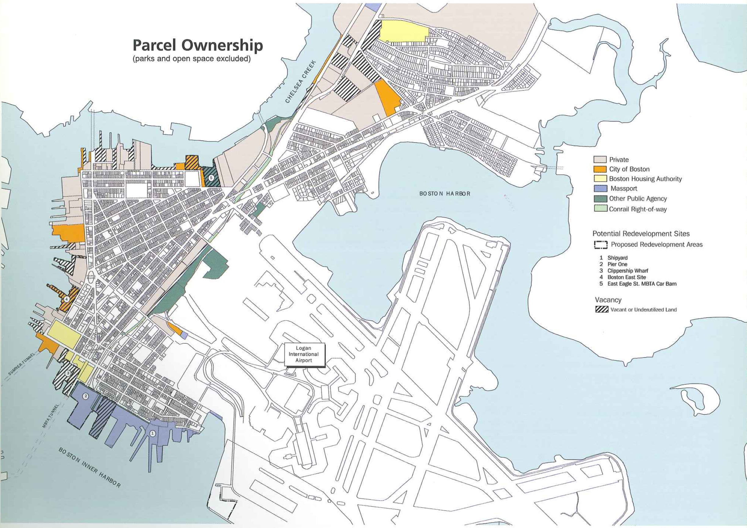
The steps necessary to implement the Master Plan can be divided into four categories of activities: economic development projects, public realm iiitpmvmnents, regulatory action and community programs.
ECONOMIC DEVELOPMENT PROJECTS:
In the short term, economic development opportunities in the retail sector will be buoyed by the growing expend? ture potential of East Boston residents and employees. In the long term, new in-Ell development potential especially along connecting corridors such as Meridian and Bennington Sheets and in Central and Maverick Squares can be expected, capitalizing on increased capture of visitor dollars and new waterfront projects.
Planning for continued economic strength in the retail sector should include the coordination and promotion of retail activities Within each commercial district through an expanded Main Streets program, the strengthening of ties between existing retail districts and key demand generators (commuters; employees, residents, toun’sts), and enhancement of the physical envie ronment.
In the short term, economic development in the hospitality sector Will be driven by development of affordably priced extended Stay business/tourist class hotel rooms within the McClellan Highway corridor and proximate to Logan Airport. In the long term, development of luxury waterfront hotel rooms may follow successful completion of the proposed East Boston water front residential developments with ancillary waterfront enhancements (Le. water shuttle, open space, marinas, and other attractions).
Planning for continued economic strength in the hospitality sector should include the coordination and promotion of East Boston retail districts and attractions for visitors to Boston, the encouragement and promotion of waterfront revitalization especially including ancillary waterfront enhance ments such as water shuttle, a waterfront trolley, open space. marinas, and other attractions, and enhancement of the physical environment.
In the short term, economic development in the office and R&D sectors will be seen primarily by increased use of upper floors (rehab and inufill) in exist" ing commercial districts and corridors oriented to business and professional service sector occupancy. 1n the long term, development of new commercial office space on the wateriront may fol low successful completion of the proposed East Boston waterfront residential developments With ancillary waterfront enhancements (Le, water shuttle, open space, marinas, and other attractions). Planning for continued economic strength in the office and R&D sectors should include promotion of East Boston retail districts’ revitalization, continued development of the hospitality sector, the encouragement and promotion of waterfront revitalization, especially ancillary waterfront enhancer ments such as water shuttles, open space, marinas, and other attractions, and enhancement of the area’s physical environment
In the short tenn, the development of new industrial facihties within the McClellan Highway corridor to serve current under-supply of industrial space Will strengthen the industrial sector. Long term economic development goals for this sector require that sufficient land he zoned for these uses, including sites presently used for these purposes. Planning for continued economic strength in the industrial sectors should include the marketing of East Boston to targeted marine demand sectors (reere~ ational and commercial boat owners, marine service providers, and tourists), Ihe development of a strategy for subsidizing critical marine infrastructure improvements, and enhancement of the physical environment.
In me short term, luxury rental development on the waterfront and moderately priced in-flll ownership and rental development in the neighborhoods and existing commercial districts are expected to characterize the residential sector. In the long term, development of luxury condominiums or co-ops 0n the waterfront should [c)llow successful completion of the proposed East Boston waterfront rental developments With ancillary waterfront enhancements (Le. water shuttle, open space, marinas, and other attractions). Planning for economic growth in the residential sector should include promotion of the revitaln ization at East Boston neighborhoods and retail districts, encouragement and promotion Of waterfront revitalization, especially ancillary waterfront enhanee~ ments such as water shuttle, open space, marinas, and other attractions, and enhancement of the physical environment.
Public Realm Improvements recomi mended by the Master Plan are:
Create the Massport portion of Harborwalk as a first phase of Masspott Piers redevelopment initiative.
Facilitate formation of a museum by providing temporary space to various cultural interest groups to develop a business plan and program outlines, in]? tiate fund raising, conduct market [easibih’ty and design studies, and other necessary efforts to developing the museum recommended by the Master Plan.
Expand open space by creating parks at the public urban wilds location, Piers Park Phase II: and Pier 5, and public access to and along the water at Hess Oil and Boston East sites.
Design and creating distinctive signage and streetseape improvements for waterEtom streets along the East Boston waterfront from Marginal to Condor Streets-the bWaterfront Way.
Facilitate private water transportation projects such as the creation of a water shuttle service between Shaws Supermarket, the North End and Charlestown, and a waterfront trolley service linking Central and Maverick Squares With the Marginal Street water" front.
Regulatory Actions recommended by the Master Plan are:
Establish Urban Design Guidelines for waterfront and Harborwalk, historic districts and commercial district centers in order to ensure appropriate building scale and character of the waterfront, preservation of public spaces and the street environment, and respect of the historic fabric of the residential neighborhoods.
Use Article 80 Development Review of the Zoning Code to review proposed development projects and ensure participation 0f the community.
Develop a Municipal Harbor Plan for East Boston to be undertaken as soon as possible in order to address the issues associated With the Chapter 91 Waterways regulations, such as public access, protection of public interests in tidelands, and maritime industrial usage. It is important that this study be undertaken both with a view to East Boston’s development as well as the role East Easton’s waterfront should play in the larger Boston Harbor context. As part of the Municipal Harbor Plan, supporting commercial uses within the DPA and the de-designation of Boston East as a DPA site should be investigated.
Modify Current Zoning The current zoning, the product of a 1997 study undertaken by the ERA in conjunction With the cemmunity, is largely consis tent with the Master Plan With the exception of a few changes. The [oilowing modifications should be afforded top priority as the tool for accomplish, ing neighborhood enhancements:
Expand the Main Streets Program to Orient Heights and Day Squares. Main Streets is a program through the City Of Bostonis Department of Neighborhood Development. The program is intended to improve the physical appearance of neighborhood uMain Streets“, offeiing matching grants for facade improvements as well as funds for lighting and landscaping. The programs is also intended to build a Community of businesses in a neighborhood business district that will engage in joint marketing efforts. Staff members of Neighborhood Development and Main Streets are available for technical assistance. Day Square and Orient Heights business and neighborhood constituencies should submit applications to the Main Streets Program so that it can be extended from Central and Maverick Squares to bolster these neighborhood commercial centers.
Promote HomeWorks as a means of rehabilitating historic buildings. The Department of Neighborhood Development sponsars lids giant program aimed at assisting homeowners Who undertake historically appropriate exterior repairs and improvements.
An outreach and educational program should be targeted to hisioric: neighborhoods through a coordinated effort of city agencies, neighborhood associations and local financial institutions.
Create a program for entrepreneurs to facilitate training and creation of busie nesses wilhin existmg East Boston comu mereial districts.
The strength of a neighborhood shopping district relies on both large Chains that bring a diversity of necessities at reasonable cost, such as supermarkets and drug stores, and shops that are owned by residents of the local and surrounding market areas and Which reflect the interests and culture of the community. The Cityis Small Business Assistance Center should be used as a resource for these locally-owned shops. Technical assistance with business development, administration and marketing is available through the center. Also grants for up to $2500 per client are offered. The Center Will also help businesses obtain loans and build credit histories.
Implement traffic calming measures. Trafiic calming in East Boston is primate 1’in aimed at measures to Limit airportgenerated and highway bypass traffic from using local streets. Measures to slow traiiic speeds are most appropriate along Benningtori Street between Neptune Road and the Revere boundary, where traffic volumes are heavy and fast-moving during peak hours. Such measures include signals with a progression timed for slower speeds. protected pedestrian crosswalks and signals at key locations such as META stations, nan t rowing of the travel lanes, and restoraui tion of onestreet parking in certain Ioca i tions where it has bEen eliminated. It is also important to maintain and enforce existing traffic calming measures to pro) tect neighborhoods from airport traffic impaCts. These include restricting airport access from local streets to residents only atjeffries Street gate; using police details to restrict turns to local streets at Neptune Road exit ramps and to. keep airport traffic destined for the Sumner Tunnel on the highway; and to create discontinuuus 0ne-Way street pate terms to keep through traffic on arterial streets.
Establish a Neighborhood Transportation Association (NTA) under the auspices of the ERA and the Boston Transportation Department [:0 provide an effective mechanism for continuous tracking and updating of transportation conditimis and issues and. for community participation in the resolution of transportation issues. Funding for the NTA should be explored with CARAV VAN for Commuters, which provides assistance in forming and sustaining similar groups.
Massachusetts Small Business Development Center Network (MSBDCN)
The MSBDCN is one of 53 state centers that provides consuming and technical services to small businesses and entreu preneurs. In Massachusetts, the M5131)CN is a collaborative effort among the Small Business Administration, the Massachusetts Department of Economic AHaiIs, and the University of Massachusetts at Amherst. Each year, MSBDCN counselors assist thousands of individuals and businesses, helping raise millions of dollars’itl capital and providing numerous educational programs and seminars. In addition, there is 51 Minority Business Assistance Center, located at the UMass-Boston campus, which focuses on helping minority ensrepreneurs through Minority Business Programs, funding issues, and international trade.

This work is licensed under a Creative Commons Attribution-NonCommercial 4.0 International License.